You can take the bus exclusively to thru-hike (no out and back needed) Segment 7 of the Colorado Trail between Copper Mountain and Breckenridge (or the opposite way, of course). I am going to explain how I did it from July 26-28, 2023, with photos! Segment 7 is 12.8 miles with 3,674 feet of elevation gain located in the Dillon Ranger District. You hike across the Ten Mile Range, where you enjoy the eastern views of Breckenridge, Lake Dillon, Torrey’s and Grays peaks, Keystone, Georgia Pass, and Boreas Pass. Looking to the west, you enjoy views of Copper Mountain, the Ten Mile Range, Vail Pass, the Holy Cross Wilderness, and the Collegiate Peaks.
- Coming from Denver, (or a number of places such as Grand Junction), you can use Bustang or Pegasus to get the Frisco to begin your journey. Note that Pegasus is a small van style service that does not have extensive luggage storage, but if you have a small pack, it’s definitely doable.
- Check the bus schedule for the free Summit Stage buses
- Unless you are getting off at the very end, you need to pull the cord for your stop, or the bus may not stop if no one is there. You can ask the drivers for help if you need it!
- Google Maps is usually fairly accurate as well but can be slightly off sometimes, so refer to the bus schedules or ask the drivers to be sure.
- I recommend the COTrex app for offline maps – although, as it happened, I got good cell reception a large portion of the trail due to the proximity to Copper Mountain, Frisco, and Breckenridge.
- There are lots of resources for the Colorado Trail – of course, I recommend the two books put out by the Colorado Trail Foundation, the guide book and data book, and the Far Out (formerly Guthook) app, in which users update latest conditions. Here is a breakdown of the segments.
- My gear was a bit heavy since I was carrying a two person tent and not splitting gear. See my LighterPack.
- If you need a place to stay, our favorite place is the hostel/hotel The Pad Silverthorne, which is 5 minutes walk from a bus stop in Silverthorne. I love Frisco, Silverthorne, and Dillon.
- If you have a “layover” at Frisco Transfer Station, Outer Range Brewing is a coffee shop by morning and brewery with Birdcraft, a delicious chicken place, by afternoon/evening.
- Silverthorne favorites include Red Buffalo Coffee and Sauce on the Blue
Day 1 – Frisco to Copper Mountain
Nick and I were already in Silverthorne staying at The Pad for Noah Kahan at Dillon Ampitheather, which we also did completely by bus. We took Bustang from Denver to Frisco, and used the free bus to get to Dillon Amphitheater.
Nick headed on Bustang back to Denver to work and take care of the cats, and I grabbed my backpacking pack and headed on the bus to Frisco Transfer Station. I hopped on the bus to Copper Mountain and got off at the Copper Mountain Entrance station, which then has these convenient instructions on how to get to the trail. I followed the instructions to get to segment 7.

This is what the bus stop looks like at Copper Entrance.

This is what it looks like to approach the Rec Path.

You stay on the paved Rec Path for a bit, and have a nice walk that looks like this with lots of bikers.


Once you get to this sign, you know you are at the trail. I headed toward “Denver” or left to hike Segment 7.

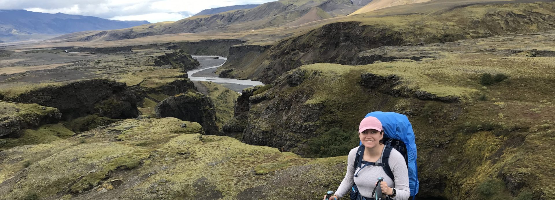
I was not planning to hike far the first day, but find a spot to camp and relax and save the big climb for Day 2, since I had 2 nights to spend before meeting Nick again for another backpacking trip. So I stayed in sight and reception of the road and Copper Mountain, but it was still pretty and relaxing.

You can see the location of my campsite on the COTrex screenshot below – it was less than a mile out, near the water source marked on Far Out. The water source was a nice creek to filter water from. 
I had a good portion of the day to relax at my campsite with my ultralight hammock. And my campsite was right next to the trail, so I talked to lots of people passing by – day hikers, bikers, and thru-hikers for the Colorado and Continental Divide Trail.

I spent a lot of time reading on my Kindle – on this whole trip, I actually finished an entire book start to finish and read about half of two other books.

It was a beautiful evening. It didn’t rain until dark, when I was in my tent, but in my bomber backpacking tent, I was definitely super safe. I went to bed early to prepare for the climb the next day.

Day 2 – Segment 7 Climb
I woke up at sunrise the next morning and enjoyed some nice coffee and breakfast before packing up and heading out.

It was up and up and up, but with a cool, beautiful morning, felt great. I saw a couple of people camping and the first day hikers I ran into were solo older women, very cool. I started in the forest with lots of water and lots of flowers, and mountain views you knew would just get better and better.

I took a snack break at the trail junction; as you can see, there were bunches of columbines at the base of the sign. One nice thing about the Colorado Trail is the clear trail markers everywhere and good trail conditions, with volunteers doing annual projects to keep the trail maintained.

There were lots of wildflowers as I continued to climb and climb. The mountain and town views started to get better and better.

Every so often I’d like back at the steep trail I had come up and check out the views.

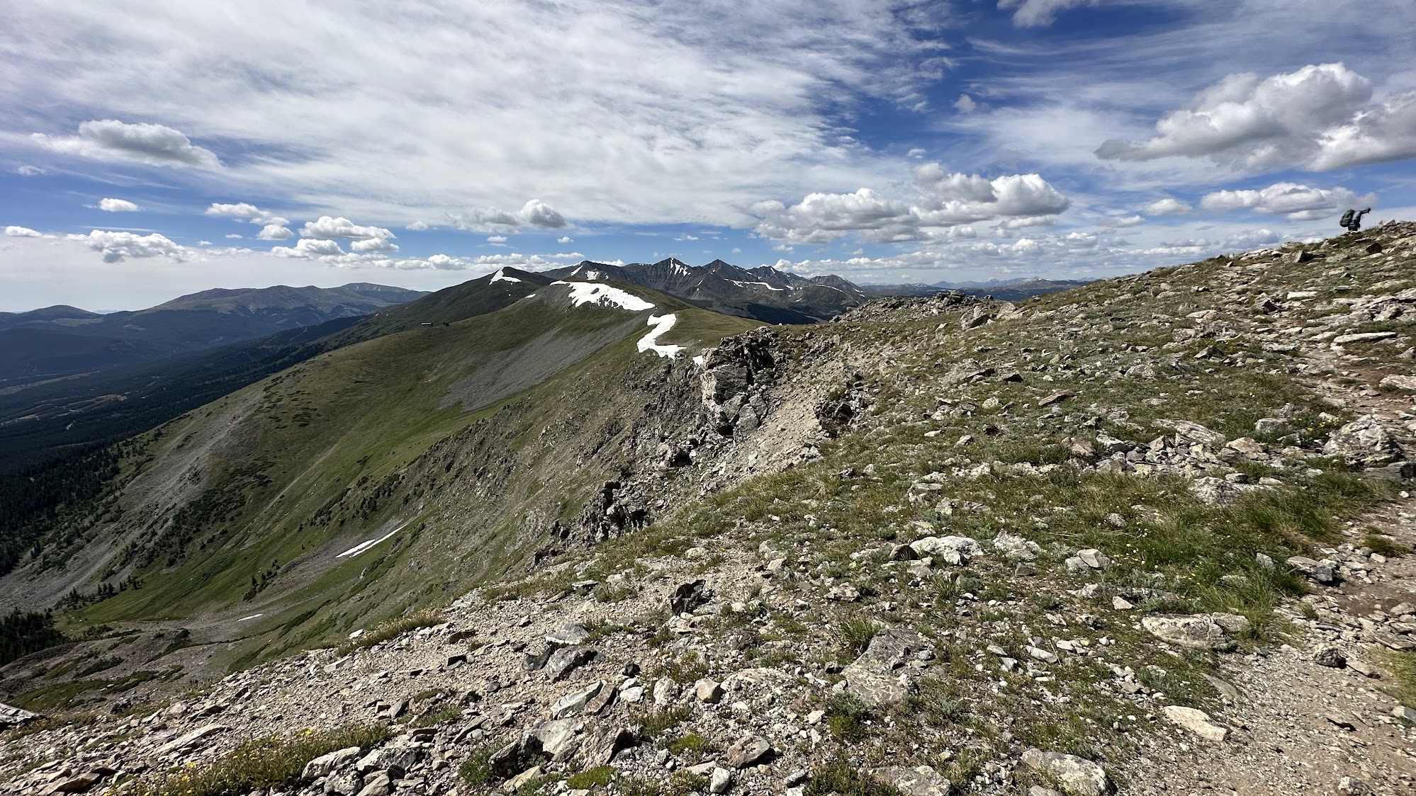
Soon enough, I was starting to get above treeline into open single track.


I was smiling the whole way hiking this trail in such beautiful weather. The trail snakes along the side of the mountain, but it is always solid and not too scary to walk. I mean, this is the high alpine hiking you dream about. Flowers in the breeze, gorgeous mountains, and blue sky. Snow hanging out and contrasting with the green landscape, but no snow or mud on the trail.


Looking back to see where I came from:

Finally I made it to the top of the ridge. You top out at about 12,500 feet, right near Breckenridge Ski Resort.

Yes, this is how close to the resort you are; that is the chairlift.

This was about as good a place as any to take a lunch break, which I did, even though it was only 10 ish am or so. Being up before 6, I was definitely hungry after the 2500 feet up.

Here is a zoom of the mountains, with their beautiful colors showing. It is hard to capture in photos or videos the majesty of the mountains.

I carried along the ridge to the section where you start to go down the other side, toward Breckenridge and Frisco. Looking back, I loved this view. I met a bunch more hikers and bikers up here, including a group biking the entire Colorado Trail. I also met a solo guy who had hiked the CT and CDT and was back again. He gave me good campsite suggestions.

Then as much as I had been going up, it was time to go down, and down and down. This was steep but once again, a good trail and not too scary. I could now see Lake Dillon. There were tons and tons of flowers on this side too, but different kinds.


Then I came to this beautiful view, which reminded me of nearby hikes like McCullough Gulch.


I enjoyed the views of Lake Dillon as I descended down into the forested section again.

Among the trees, it flattened out with fields of wildflowers next to flowing creeks. I found a great spot with hammocking trees and set up midday.

My view was incredible, with the relaxing sound of water and tons of flowers.

Here is the location. It was a little sooner than I was thinking I would camp, but I loved the spot so much, and since I had an entire day to spend, thought it was worthwhile, even if I’d have six miles to hike the next day.

Once again, I hammocked and read a lot. Occasionally it threatened rain, but never did. I wore the gloves, socks, and rain jacket for the mosquitos more than anything, along with my head bug net. I had a fabulous, relaxing day. At dusk, it got chilly surprisingly fast, so I went in my tent before nightfall to lay down. This was the coldest night I had, and bundled up in my jacket and quilt – but my gear is great for temperatures down to freezing, so I stayed warm. 
Day 3 – Six Miles to Gold Hill Trailhead
I enjoyed another sunrise and early breakfast and coffee at my gorgeous campsite before packing up and heading out early.

I had about six miles to go mostly downhill. I got to Miner’s Creek, another potential campsite area near a jeep road, which had lots of water and campsites. I continued to meet lots of backpackers, mostly solo. After Miner’s Creek, the hike started to have a lot of beetle kill trees, and various dead/downed trees. 
I was motivated to keep a good pace to get to town and meet Nick for our food, and was able to do so. Even with some ugly trees, there are still gorgeous views, especially if you look back on the mountains you came from.

The last section is very open and exposed as you hike down to the road. It was already hot, and it was only morning.
This is what the trailhead looks like at Gold Hill:


I turned to walk along the Rec Path. If you wanted to catch a bus to Breckenridge, you would go to the bus stop on the same side. I, however, was headed to Frisco, so I needed to cross the highway – but there is an underpass for hikers!

There is a trusty sign with the trail symbols under the highway.

I walked to the bus stop, which was shaded and had a trash can for me to dump my trash.


There are also handy instructions and bus schedules posted at the bus stop. 

And then, I zipped off to shorts and changed to my sandals, caught the bus, and met Nick at Outer Range Brewing, where he was waiting with my chicken bowl.
Overall, this hike is really beautiful and I enjoyed it a lot. Stretching it out over a few days was easy and fun, and taking the bus allows an awesome opportunity to thru-hike a beautiful section of the Colorado Trail.