Iceland Day 6: Laugavegur Trail to Þórsmörk

I was excited for my final day of the trek. I knew I had a bus to catch by 6:00 pm, but was confident based on the other days that I could finish the final 9.3 miles in good enough time to head to the restaurant. Yes, that’s right, there was another restaurant at the end of the trail.

Of course, it was raining again in the morning when I woke around sunrise (5:30 or so), so I had a similar dilemma to the previous day. I was able to make breakfast, then packed up my tent during a brief stop in the rain. I set off on the trail in the rain around 8:10 am. Once again, overall elevation gain was a loss this day – and I kept hearing it was “mostly downhill” from here. There was more up and down as we started, and lots of black sand and stunning scenery.


IMG_7450.JPG

There was a fairly steep downhill section in the sand where I fell on my butt. It was not a dangerous section, but it made me use caution and approach the downhills very slowly.

As I was slowly going down a hill, I saw one of the British chaperones who had helped me with my pack. “This is hard for you, isn’t it?” she said. And yes, I was definitely challenging myself. But I knew I could do it, even if I had to slow down to a half pace. We chatted a bit before she forged ahead.


IMG_7454

There was a bridge section that included a built in grip as you climbed up a steep section. This was actually less stressful for me as the structure in place than some of the very steep up and downs of the first day. The British woman had used the word momentum that first day, and I kept thinking about keeping my momentum up hills.


IMG_7466

The rain had cleared up by 9 am, and it ended up being a gorgeous day with lots of sun. I met some guys who had also camped the night before, and had a Garmin GPS with weather. I guess it said the rain would stop at 9 am so they went back to sleep, woke up, and packed up at 9. And the weather prediction was right. This holy device said rain would start again around 3 – probably when we would all be finishing up the hike (and rain didn’t start until 2:30, so it was pretty close).

I was seeing the start of fall colors all over the landscape (and I love the deep red in the rock below):


IMG_7479.JPG

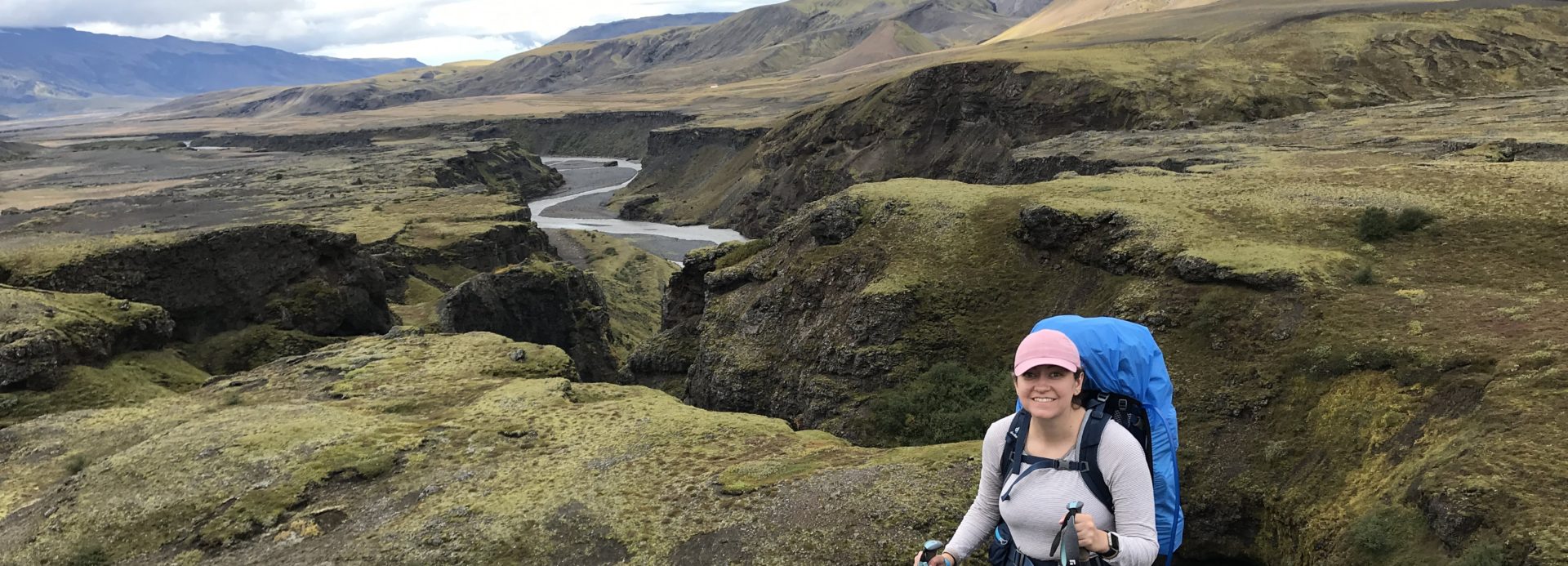
And I think I started taking photos just to show how steep and up and down I had to go:


IMG_7545

It even felt warm enough with hiking and the lack of wind and rain to remove my layers. This might be one of my favorite photos, with the “unicorn” mountain in the background:


IMG_7562

The landscape flattened out again, for some more long walks through black sand, observing fall colors and the glacier. I continued to meet up with people I’d seen all along, including the British chaperones, the Utah group, and the Israeli couple.


IMG_7598

It was amazing to see sheep in what felt like the middle of nowhere:


IMG_7621

There started to be trees and the landscape started to change. And we were not to the last uphill yet, as you can see from the trail below. Luckily the beautiful vistas were worth it.


IMG_7685

Soon we would come to a big river crossing, the biggest yet. Whenever I got to a river crossing, it helped me to know that lots of other people were around. This one had several parts to get through, the deepest being knee deep. A lot of people really struggled with the cold temperature. And also tried to cross in the narrower parts of the river, making it more difficult. It’s hard when your feet are in pain from cold to remember that the widest part of the river is best, even though it looks further and harder to cross. I felt proud that I did well at this part that many struggled with. I struggled a lot with the fear of falling and heights, but did better with the crossings. You have never been gladder to put on your two layers of socks (toe sock liners and wool socks) and boots then after your feet have been through this river.


IMG_7730

And suddenly, you are in the forest. After a nearly completely treeless hike, it was strange to be among the green trees, with hints of orange and red signifying the beginning of fall.


IMG_7749

And then there was a sign indicating Thorsmork was near, and multiple destinations were at the endpoint. And guess what. MORE UPHILL.


IMG_7770

But then I reached the peak started to descend, beautiful scenery all around. Walking toward a black ash field and the glacier and green-black mountains. And then I reached the post labeled “LV 1” and the sign indicating the official end of the hike (or start for those going the other direction).


IMG_7805At this point, I cried with joy. And emotion. Pride in myself. I had never done anything like this. And I did this hike in the wind and rain, went up and down steep hills with frightening drop-offs, crossed rivers of glacier runoff. All by myself. It was around 3 pm at this point, so I’d done the whole thing in around 7 hours this time.

I was overjoyed and followed the signs to Langidalur. I made it to the huts with a beautiful glacier backdrop and volcanic fields, with buses driving around the huge black rocks. I saw one of the British chaperones and we chatted, and I finally got use a bathroom.


IMG_7812

I then asked the warden how to get to Volcano Huts. Volcano Huts are in Husadalur, 2 km away. Either place you catch the Sterna bus is a 2 km walk. I tried to think of how much 2 km was (it’s 1.2 miles) and wanted to cry. I thought I was done. She assured me I didn’t have to go back up those stairs and it was a fairly flat walk.

Thinking of the restaurant and friends that awaited me at Volcano Huts, I set off for more hiking. “This freaking hike doesn’t end,” I ranted to myself as I walked and walked before finally getting to Volcano Huts.

I entered the restaurant and saw my Israeli couple friends, Tal and Or. I approached them, and then some people sitting next to them said hi. I blinked. These were my Canadian friends I had seen at the bus the first day. We all made it!

There was a buffet lunch with lamb stew, salad, lots of delicious bread, and coffee and cakes. It seemed really good or maybe I was just starving after backpacking 33+ miles. I sat with Tal and Or and we enjoyed such luxuries as not just food and indoor heating, but electricity and WiFi. We had a couple of hours at this point until the bus came.

I ended up seeing my Utah friends as well and chatting with them. Trekking the Laugavegur Trail is like being in a club. No one else can really understand what you have been through, or the beauty you have seen, which can’t really be captured in photos. I bought a patch that said “Laugavegur Trail” (I kind of wanted a t-shirt with the trail on it but it was like $40 USD).

Eventually we boarded the bus and the bus ride started incredibly. We crossed many, many, rivers through the volcanic wheels on a bus with gigantic wheels, the glacier and beautiful mountains still looming in the background. Someone on the other side of the bus said they spotted an Arctic Fox (they are scared of people but I’d read of people spotting them in Thorsmork).

Eventually we got to more normal roads and stopped quickly at a waterfall, Seljalandsfoss. This was on my itinerary for my drive, so I knew we must now be close to the Ring Road.

It was a sleepy bus ride back in the rain to Reykjavik. Back to Harpa, and then a bit more trekking along the flat sidewalk to Kex. I felt odd in my unshowered, backpacker-y state as there was a hip-looking comedy show (people laughing at a woman speaking Icelandic on stage) that night in the basement and locals were around, dressed up for the evening. There is a fast food joint across the street that was still open (around 10 pm maybe?) so I got a hot dog and fries, which I devoured before taking the best shower ever. Kex has individual little rooms for showers, and the standard in Iceland seems to be waterfall showerheads. Plus our Snaefellsnes tour guide told us the shower water in Iceland was heated geothermally, so you can feel a bit less guilty about using up hot water.

The Laugavegur Trail was extremely hard but very rewarding. I couldn’t help but smile at the scenery around me even as the rain and wind poured down. At some parts I thought, can I do this? I had to put all of my focus into believing in myself. I thought maybe I would be slow as I often seem to be in Colorado hiking, but I managed a decent pace somehow, even with all my photo stops. People have talents, and hiking and backpacking do not come easy to me. People say the trail is technically easy but weather makes it difficult (I guess??? Not for me). What a remarkable experience. I still cannot believe I did it sometimes.


Iceland Day 5: Laugavegur Trail to Emstrur

Today I had 9.3 miles ahead of me, estimated to take approximately 6-7 hours. The night before, in the restaurant, I’d met a couple that was doing the trail in the opposite direction and said there were lots of really flat sections ahead, although more up and down and some big river crossings (they said thigh-deep for one!).

I woke up to rain of course. This is always a dilemma. Do you try to wait out the rain to take down your tent? Or, it could be raining for a long time. You can only delay for so long. I could afford to wait a bit longer. I was especially pleased with my speed the previous day, and actually thinking I might get to the next camp too early and be bored! I made my breakfast and waited a bit.

Well, what will always happen is that as soon as you take down your tent while it is raining, it will stop raining RIGHT WHEN YOU ARE DONE. Of course. But I was actually quite pleased with my skills taking down my tent in the rain. I was proud of myself for successfully camping solo for my first night. So I was in a surprisingly good mood given the situation.

I set off around 8:30 am, and starting by getting to traverse some of the beautiful green scenery I had been overlooking the previous day. The photo below shows the trail with people trekking.

IMG_7091

There was my first around knee-deep river to cross. I changed my shoes at the river.

IMG_7093

You can see the hikers below preparing to cross. On this crossing, my feet got so cold that they stung in pain. However, I was successful by having proper equipment (Keens and trekking poles), and crossing in a wide part of the river where the current is less strong. I saw some of the British chaperones throughout this part of the hike and chatted with them as I went along.

IMG_7095

The scenery would continue to change from these gorgeous electric green on black mountainscapes, with a few more steep up and downs….

IMG_7112

To the flat, black martian landscape. Where you walk through volcanic sand. It’s kind of odd. And get to view this gorgeous, glowing glacier. I kept trying to take pictures of it, not realizing it would be a featured player throughout the rest of the trek.

IMG_7137

I loved seeing flowers in this strange landscape. I love wildflowers and have been hunting them this summer in Colorado, so it was amazing to see what grew here among the black sand.

IMG_7150

There was a rushing river with (thankfully) a bridge from which I took the photo below.


IMG_7225.JPG

I loved seeing the progress I made in these Laugavegur trail signs. Although they are in kilometers, so I’d try to make the conversions in my head to miles and somewhat fail and just say to myself, that doesn’t seem too far!

IMG_7236

This black sand section stretched on seemingly endlessly. You would see tiny dots of backpackers way ahead of you on these long, black, sandy stretches. Every so often I’d catch pace with one of the British chaperones or someone else I’d met along the trail and chat for a bit, or ask strangers to take photos of me.

As you can tell from these photos, the weather cleared up nicely and you can even see some blue sky and sun. For Iceland, this weather was just amazing.

The photo below is looking behind me on the trail and gives you an idea of some of the vistas I saw, and how long the trail stretched out in each view.


IMG_7283

Look guys I even UNZIPPED my rain jacket. Not exactly balmy, but pretty nice by Icelandic standards!

IMG_7284.JPG

I caught my breath with one of the British chaperones and we looked upon a black, endless vista. Where was this camp? That’s when the young British women on break from university came around the bend. They were walking the trail to note markers that needed repair. What a remarkable way to spend a summer! They assured us that our camp was just around the bend, as we came into the breathtaking view below.

IMG_7297

Wow, what an incredible place for a camp. We would be camping under the glacier (which trust me, looks much closer in person and glows magically). It was around 2:40 pm. Once again, I had done the hike in less time than I had expected (around 6 hours for an estimated 6-7 hour day).


IMG_7308I asked about hut spaces. There were spaces, but I would be the only one with a group that was together if I chose that. I asked about weather for camping, and the warden said it looked good. It was gorgeous out at this point, so camping sounded great.

I walked down to the campsite. I thought the previous couldn’t be beat for beauty, but this was lovely with a creek running nearby and a glacier right above you. I was the first to pitch in this lower area of the camp, although many would join me later. Someone had already built the site with the rock walls below, so I used those to guy out my tent.


IMG_7321

The British girls had mentioned that there was a hike from camp that was well worth doing to a canyon. Markarfljótsgljúfur canyon – yes, I googled and copy and pasted that. I was hanging around camp wanting to do the hike – the weather was good and it was not dinner time yet, even for an early dinner. I happened to meet some hut people – most of the group was a family trip of people from Utah. They were all hut partners. We set off on the hike.

This canyon is remarkably stunning. It has incredible shades of green and red.


IMG_7325.JPG

The folks I was hanging out with were very nice, and we talked about our experiences so far and life in Utah and Colorado. We discussed how so few people in the world had seen this canyon. It was this surrealist canyon, with no information markers or railings, in an uninhabited place in Iceland.


IMG_7331

The two younger guys in the group were great at posing Instagram photos, so took this for me (it’s definitely a different look to those cute travel photos of girls in European cities wearing sundresses, but 2 hats and rain pants was practical, dammit!):


IMG_7368

We ended up doing the whole trail, which took maybe an hour or more?

IMG_7379

We continued to get stunning glacier views:

IMG_7417

I started to cook dinner outside of the hut, and some of the hut people came to sit with me. How can you beat this view?

IMG_7426

I made two of my dehydrated meals – I had an extra due to my changed plans. It started to get too cold, so I retreated to the campers’ tent which had picnic tables for cooking to make my hot chocolate. The high school group was there from England, making it a lively scenery. I mean, it was quite impressive that they were cooking their own meals (although some of them mentioned they had forgotten their shoes for the rivers – how do you do those crossing without shoes?). I had brought my toiletries up with me – it was a bit of a trek down to my campsite for the night after brushing my teeth.

Also, maybe this is kind of gross, but I didn’t shower. There were pay showers available (around $4 USD), but there was always a line. It was also really cold, and I would definitely not want wet hair to camp. The showers were inside, but you’d step right out to the cold. I used makeup wipes as kind of a “shower” but didn’t really feel like doing much more, when I knew I could have a shower the next day.

I set up my sleeping pad, pillow, and sleeping bag, went to sleep before it got totally dark. I actually got too hot in the night. I have a 15 degree F bag, and it got to around 40 F that night according to the thermometer on my pack. I also had chemical hand warmers and all my layers on. Once again, I was so utterly exhausted that I fell asleep quickly (which I don’t typically) slept like a log throughout the night.

Both nights camping I fell asleep to the sounds of people speaking all kinds of different languages and with different accents. It was amazing. I don’t know when I’ll ever experience anything like it again.

Iceland Day 4: Laugavegur Trail to Alftavatn

I woke up early (around 5-5:30) to get started early on the 15 miles hike to Alfavatn. I knew that each section of the hike, 7.5 miles, was estimated to take 4-5 hours, so I wanted as much time as possible to complete it.

There were sheep right outside the hut when I got up in the morning, and it was a cold trek to the bathroom (separate building).


IMG_6707The kitchen was locked until 7 am, so I used my backpacking stove to make my breakfast outside.

I started off around 6:45. The weather was good (not raining or windy), so I was eager to start. Plus the sun was rising beautifully over the painted mountains.

The scenery starts jaw-dropping and continues to get only more remarkable. It’s these gorgeous, multi-hued mountains with steam coming up around them that makes everything seem mystical. It’s like being in some Lord of the Rings fantasy novel.


IMG_6742

IMG_6767I knew there was the most elevation gain and distance this day. But it did not necessarily prepare me for the difficulty of this hike, which challenged me in different ways than hiking in Colorado. I have a fear of heights, and it’s really a fear of falling down a height when there is a steep edge or drop off. Those mountains/hills below require going up and down some steep heights with 30 pounds on your back. It was quite scary for me sometimes, and I used my trekking poles and went slowly.


IMG_6839The scenery just kept changing as the hike went on but was gorgeous in different ways. While I was hiking alone, I’d see people fairly frequently along the way. It certainly didn’t feel crowded, but I also didn’t feel I would be in danger if something happened to me- someone would come to pass soon enough.

Throughout the hike, most of us kept our rain pack covers on. It just made sense as it would rain enough that taking it on and off was just extra work. This first day, I kept my rain jacket and pants on all day. Even when it wasn’t raining, this gear helped protect against the wind (and this was a “good” weather day). And yes, I had a 3 hat system that is super cool looking in the picture below. I kept my baseball cap on to protect my face from sun and rain. The beanie is for warmth, and then I’d put the rain hood on to protect against the rain.


IMG_6843

Below you see a trail marker. The trail is very well marked, and when crossing a river or up and down mountains I got used to looking for the wooden stake. I didn’t use my GPS, but it was good to have as a backup. I can see how in fog or bad weather it could be hard to follow the trial, and some markers had been blown down (later, I’d meet some young British girls who were spending their summer break from university marking any issues with trail markers!).

IMG_6866

We started running into snowfields, some of which we would end of crossing during the trek. One other good way to follow the trail was to follow the footprints.

IMG_6878

The scenery changed and turned black:

IMG_6886.JPG

I went up and down mountains among gorgeous electric green against black, orange, and white steam:


IMG_6905And then, it started feeling like walking into Mordor. Windy, rainy, and black:

IMG_6916

Those little ant like figures are trekkers walking over the snow field:

IMG_6925

You run into a memorial to a 25 year old who died in a blizzard (apparently ignored the warnings of the hut wardens). And what is crazy is that I think here you are maybe 20 minutes from the next hut, Hrafntinnusker. So close yet so far indeed.


IMG_6918

I could not believe I was already at the first hut. I had made it by 11 am. So I’d taken a little more than 4 hours to do the first part of the hike. Lots of people had passed me, and I knew I was slow. Lonely Planet and other guides said this section would take 4-5 hours. I was making great time.

IMG_6930Here at Hrafntinnusker, I used the bathroom and met the basically famous to me at this point hut warden, Katie. She runs the blog Feathery Travels which is a great read to prep for the trek, and is active in the Facebook group. I asked her about the Canadians I had met, and she said they had been able to switch their hut reservation to Hrafntinnusker for the previous night. I was relieved to hear they had made it! I was really relieved not to be camping here, as it was windy and rainy (you can see some rings of rocks where the tent campers camp in the photo above).

Although not typically allowed, Arctic Adventures allowed trekkers to eat lunch in their tent (it was raining and windy). I had the same lunch for every day, tuna salad packet and tortilla, and various snacks. Part of the reason I made good time on the entire hike I think was that it was too cold to stop for very long to snack or rest. Moving is the key to staying warm, as anyone who has hiked in colder temperatures knows.

I started up again 11:30, feeling refreshed. It was still windy and rainy. Here you can see the trail marker and some of the steep terrain we had to navigate.


IMG_6935

It got really cold and I pulled my Buff over my nose for warmth.


IMG_6940

The scenery continued to be stunning.

IMG_6962

I started to get into some of the most difficult (mentally challenging) sections of the hike. Some very steep uphills with my pack. I tried to focus on leaning forward, looking at my feet, and following other people up.

IMG_6964

There was one very steep downhill leading to a very steep uphill. You had to step up basically to knee level to go up the mountain with a steep drop off. I started to get really scared that I could not do this with my pack. I starting really panicking and psyching myself out. A British man and woman came up behind me. The woman said “take off your pack and I will hand it up to you.” I did so for this little steep bit, and she brought my pack up to me. I then followed them up a very steep uphill in black sand with a drop off down the side, focusing on looking on my feet, leaning forward, and following their foot steps. I found out these two were chaperones to a group of British school kids (around 17 years old). They allowed the teens to do everything including camping and cooking themselves.

IMG_6989.JPGThe picture above shows the hikers on a path I would eventually hike. And then we moved from this landscape that was like an alien’s painting to descend down a mountain.


IMG_7001The photos don’t really do the scenery justice. Seeing this scene made me cry with simply seeing the beauty of it. And perhaps with relief of having gotten this far, because it was hard. It was stunning. Jaw-dropping. Perhaps it’s the electric green against the black that makes it so beautiful.


IMG_7008

Although I was descending a mountain, the heights were less scary since it was more gradual (still plenty steep). I also knew that Alfatavn, the hut and campsite, was near the lake you can see above. I’m almost there (um, kind of). As I saw Tal and Or, my Israeli couple friends, I was joyous at being so close to camp. I also knew there was a restaurant there.


IMG_7001

I finally descended. Every time I got nervous about the heights I’d stop to just looking across the unreal scenery. There was a river to cross. I ran into a hiker who said you didn’t need to removed your shoes to cross it if you picked the right place; however, to me, it seemed easier just to change to my water shoes and cross in the around ankle deep water. At this point, it was similar to crossing the icy cold Colorado creeks.

This is the part of the creek that seems to go forever. The rain had let up and it was stunningly beautiful. But..WHEN WOULD I GET TO THIS HUT? It seemed like forever. At least it was flat. But I was getting truly exhausted, mentally as much as physically.


IMG_7057

I was so excited as I approached the huts and campsite to see the RESTAURANT. I figured even if I camped, I could treat myself to the restaurant. I arrived around 4:30. So I took around 5 hours to make the second leg of the hike (estimated to take 3-5 hours). I was proud of myself for the time I made.

IMG_7064

I asked if there were hut spaces available, which there were. Then I asked about the weather for camping that night. They said conditions would be around the same as the weather at that time, which was calm. So I camped. I actually felt like camping. Maybe I’m losing my mind. I thought this might be the most beautiful campsite in the world, but it was only my first Icelandic campsite.


IMG_7074

I pitched and guyed out my little one man tent. I was proud of my setup, and I had a plan. I planned to make my backpacking meal, and then go to the restaurant and eat SECOND DINNER.

IMG_7070
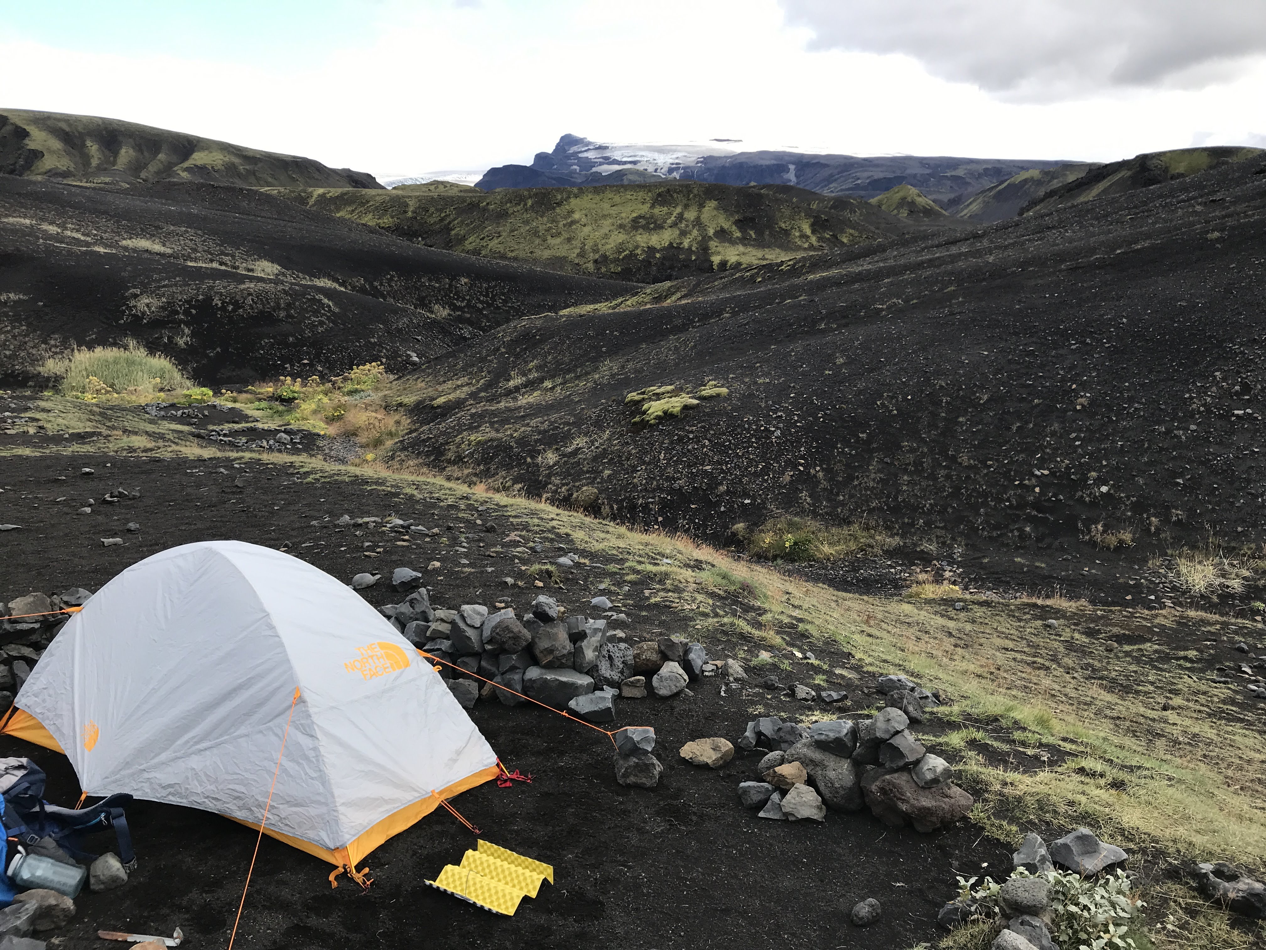
There was not a tent for campers here, so you were out on some tables in the cold to make dinner. I made my dehydrated backpackers meal out in the cold. Then I went to the little restaurant. Spending $20 USD for soup and bread suddenly sounded like the best deal ever. The chicken soup was delicious and the bread was hardy.

IMG_7085.JPGThe little restaurant had a lake view. Just so gorgeous. I wanted to get a hot chocolate next. This was part of what made camping tolerable – having a warm place to hang out until bedtime.

Then, I saw my friends Tal and Or, the Israeli couple! I was really excited, and we hung out in the restaurant for a while swapping trail stories and talking about travel in general. It was great.

When I went to bed, there was a bit of wind and rain in the evening, but I was too exhausted to be too concerned and had to put faith in my tent and my pitching skills. I feel into a deep sleep that I wouldn’t usually fall into in a tent. But straight-up exhaustion got me. And my tent held well.

This day was maybe the single hardest day of my life, but the most incredibly stunning and beautiful day. I definitely struggled at points with the heights. Physically, it was challenging, but I knew it would be, and had been training all summer. Mentally, it was more challenging than I though. Some of the heights made me question why I thought I could do it. I didn’t grow up hiking or backpacking. I was never naturally good at physical activity (I have other talents, like reading quickly and spelling). I was last picked in every sport and a dodgeball target. But I knew I could do it, deep inside. And the effort, pain, struggle, and challenge was worth it for the reward; a once in a lifetime experience. And I had new found friends that helped me along the way. People aren’t so bad; they even want to help you occasionally. And when you’re on the trail, it doesn’t matter what language you speak or what country you are from; you are going through the same, unique experience, and it makes communication easier.

Iceland Day 3: Landmannalaugar

The Laugavegur Trail is a 33.5 mile (54 km) trail, dotted with huts and accompanying campsite that make it easy to split in 4 days. I had wanted to go to Iceland for a long time, seeing everyone who traveled there posted gorgeous pictures. When looking for what to do, I somehow stumbled across this trek. The pictures were stunning. I researched the required backpacking, and thought being in Colorado gave me the perfect chance to prepare. Plus, I wanted to explore Colorado hiking anyways.

I took a hiking safety and backpacking class. I did research, went to REI, got fitted for a pack and boots. I waited for sales and looked for gear built for wind and rain. I practiced with my backpacking pack at elevation, destroyed one backpacking stove by accident, and bought another. I tried to hike or backpack every weekend in the summer. I bought new trekking poles days before the hike at REI when my old ones crapped out.

I did read Wild by Cheryl Strayed earlier this year, so maybe that inspired me to backpack the Laugavegur Trial solo. Also, I know that my pace is so often much slower than everyone else, so going on my own allows me to hike at my own pace and stop as often as I want.

Anyways, after all this preparation, I knew the weather played a huge factor and could result in my changing my plans or even canceling my trek. I allowed 5 days for the trek in my itinerary, thinking I could always spend a day in the beautiful beginning or end places of the trek.

After being delayed for a day and going on my Snaefellsnes Peninsula, I headed to Harpa Concert Hall to catch a 7 am bus with my rain gear on. As we waited for the bus, I started talking to some Canadians and found out I had been chatting with them on a Laugavegur Trail Facebook group about the weather and changing our plans. They planned to start the hike and push through to the second hut at Alftavatn, since they had a hut and were not camping.

I got on the bus, which had WiFi, and checked the weather. It was not looking good still. However, on the Facebook group, a hut warden had recommended staying in the hut at Landmannalaugar, the place you start the trek (where the bus drops you off), and then doing the trek in 3 days by combining days 1 and 2 for 15 miles total. I had been considering doing this all along anyways, since the first campsite (Hrafntinnusker) is typically the windiest and coldest.

Safetravel.is eventually put out a travel warning not to hike or camp that night. I ended up using WiFi calling (I didn’t know that was a thing? it’s awesome) to call Landmannalaugar Hut from the bus and reserve a hut bed. I felt a lot better knowing I did not have to camp that night and could start the hike fresh in the morning.

As we turned off the ring road toward the interior of the country, the scenery got just stunning. It was like being on the moon among these stunning mountain formations. The scenery at Landmannalaugar is truly jaw-dropping. It’s like being in a painting. Photos really don’t do it justice at all.

IMG_6687.JPGThe hut is around $70 but very basic. It has a mud room, shared kitchen, and the bedroom is like this (luckily no one was sleeping right next to me so I had lots of space!): IMG_6594The key aspect to the hut is that you are inside and warm, and when the weather warning says “tents will be destroyed,” you are not sleeping outside! Suddenly your definition of “too expensive” changes when faced with these conditions.

With no WiFi (certainly no TV), what do you do all day when you can’t start hiking yet? Well, there is maybe the hot spring with the most amazing mountain views in the world.

IMG_6598I went in for a bit and met some people. I also met some people in my hut – one was a geologist in Iceland for work who brought his mom and a friend along to explore. I decided to try a brief hike (preview of the trail), and the mountains truly looked like living in a painting (more on that tomorrow, see a view of the huts and campsite below).

IMG_6609

I made my dehydrated backpacking meal in the kitchen, and also had some fish soup that an Icelandic tour guide had made a huge batch of (it was delicious). I met an Israeli couple, Or and Tal, who I would end of seeing a lot as we were doing the trek on the same schedule. After dinner, I went to the hot spring which was full of people (once again, no internet or TV) and met a different person from Israel who was staying in my hut and even a couple from Flagstaff, AZ. As the sun set, people began singing in Russian. Free entertainment (they were actually pretty good singers)!IMG_6601

I met the others in my hut (you can’t really help it, it’s tight quarters!) including one guy who decided to get a hut after he couldn’t sleep in his tent the night before. We went to bed pretty early. I wanted to get an early start with 15 miles ahead of me and knowing I am often a much slower hiker than most people. I slept great in the hut despite the number of people sharing a room.

IMG_6686

Iceland Day 4: Laugavegur Trail to Alftavatn