This is my last post in my solo trip to Moab series, check out:
Day 1 post for Fisher’s Towers and Delicate Arch sunset
Day 2 for Arches National Park and Dead Horse Point sunset
Day 3 for Dead Horse Point sunrise, Canyonlands, and Arches moonrise
Day 4: Monday, March 29 – Windy Arches Sunrise and Moab Canyon Bike Ride
My last day in Moab, I woke up again for the sunrise and it was not as frigidly cold. I didn’t have to wake up as early since I was heading to the La Sal Mountains Overlook in Arches National Park, which was only a 15 minute drive away. You’ll remember from Day 3 it’s the same point where I watched the moonrise the night before.
However, when I got there it was so incredibly windy that it wasn’t pleasant to sit out and make coffee. I ended up retreating to my car to watch more of the sunrise.
Luckily, I was not far from Moab, so I headed back to get some coffee and breakfast. I had heard Doughbird was really good. It’s a donut shop that has a famous fried chicken sandwich. Apparently I was too early for the sandwich, which they start making at 11, so I got some doughnuts to bring home for Nick and I. Instead I grabbed a breakfast burrito and coffee at Love Muffin to go, and sat in the empty food truck park. It was much less windy in Moab and really nice out.
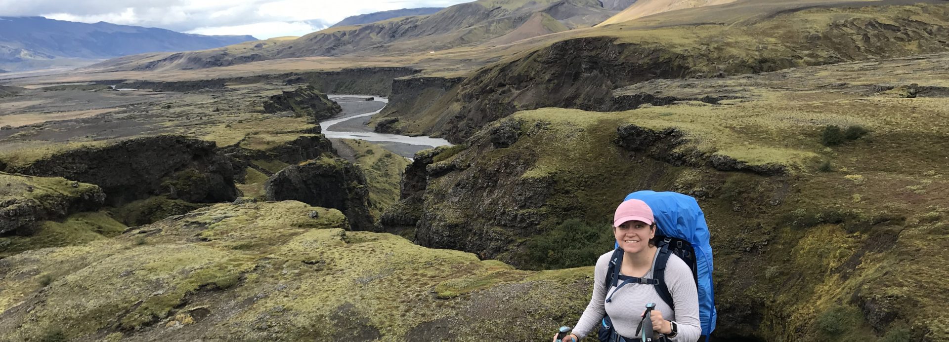
I had noticed on the last stretch of State Route 128 into Moab, there was a cool bike path alongside the Colorado River and in the canyon. I had brought my fold-up bike just in case I needed it, so I decided to go for a little bike ride. There’s a parking lot near the bike path start, and you can go 2.5 miles before bikes join the cars on the highway, so I decided to do a 5 mile roundtrip and turn back there.
It was just awesome riding along the river surrounded by red rock walls.
I passed some really cool Bureau of Land Management (BLM) campsites along the way, with some kids trying their bikes on the flat path.
After that, I headed back to Moab. There are several places that had been closed by the time I got back to Moab other days – like cafes and coffee shops – that I checked out. One was Moab Garage, pictured below.
This coffee shop had something called a Nitrocinno, which is a vanilla milkshake with nitro coffee. I got one to go and headed back to my favorite spot, the food truck park, to grab a table in the sun and read more of my book. This relaxation time was just lovely. At 11, I was first in line for my chicken sandwich. Don’t worry, I took a photo.
Even for me this was A LOT of food, so I couldn’t finish it, but it was very good (nothing beats Ingo’s chicken sandwich in Phoenix though).
By now you might imagine I was tired. I viewed every single sunrise and sunset I could in Moab. I decided to head back the scenic route again on 128 which was really nice. It was not busy at all. I stopped to capture some scenery.
It seemed like a long drive home, but it was so worth it for this lovely desert escape. I will definitely be heading back, and obviously Nick needs to visit too! I think spring, which is a tough time in Colorado, will be awesome for future visits.
This is a continuation of my Moab trip posts. See my Day 1 post for Fisher’s Towers and Delicate Arch sunset, and Day 2 for Arches National Park.
Day 3: Sunday, March 27 – Dead Horse Point Sunrise and Canyonlands
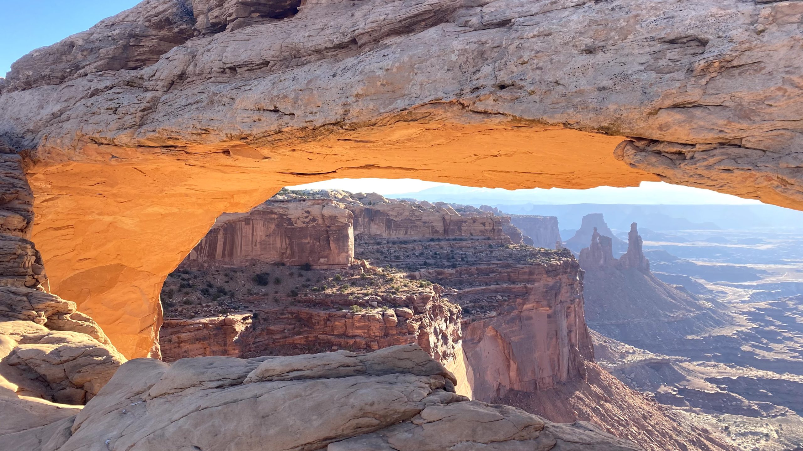
I decided to head to Dead Horse Point again for sunrise after the beautiful sunset the previous evening. I knew there was a huge area with a West and East Rim, and the East Rim meant watching the sun rise over the snowy La Sal mountains. It was a chilly morning and there was only one other car when I arrived. Even with a few more people arriving it was much less busy than sunset (no photo shoots this time!).
Once again, I brought my stove to make my oatmeal and coffee as I watched the sun’s progress.
The early morning light over the canyon is remarkable!
Next, I headed to nearby Canyonlands National Park, which is just a 15-minute drive away. It’s a huge park, and the easiest district to access from the Moab side is called “Island in the Sky,” so I focused my day on that area.
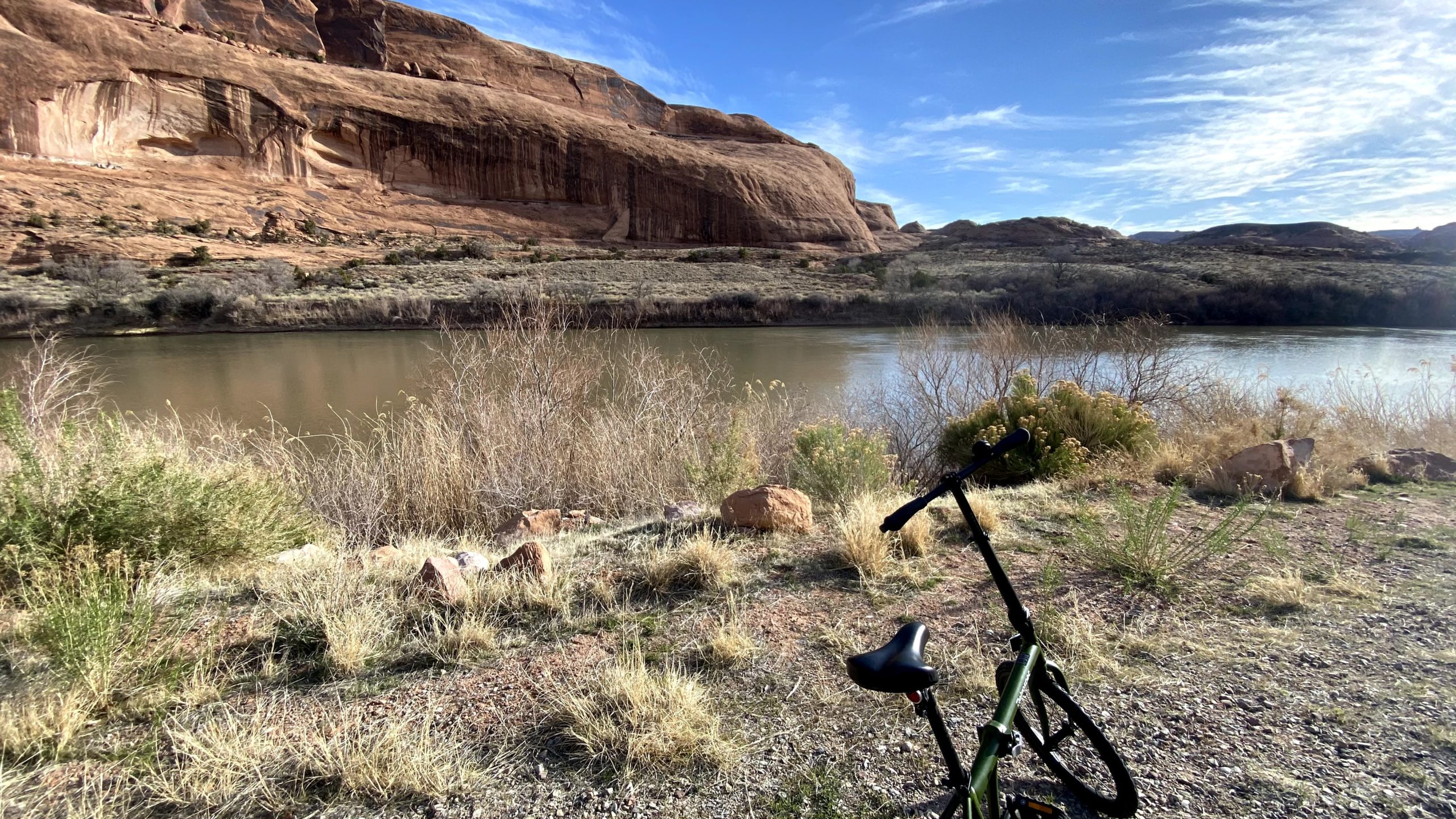
I had considered Mesa Arch instead of Dead Horse Point to start the day, which has a famous sunrise photographers gather for as the sunlight hits the arch in a perfect moment, but it looked like a smaller area that could be really crowded. I decided instead to make it my first destination in Canyonlands at around 8:30 am, which was perfect timing. The parking lot was not full (it was more than full the rest of the day when I drove by and some sunrise people were leaving. It is a short and easy hike down to the arch. Every single picture I took was magnificent with that early morning light.
After Mesa Arch, I decided to head to the Grand View Point. There is a Grand View Point Trail that runs along the canyon rim, so I took that for a while. It was not very crowded, and I really enjoyed the overlooks.
After this, it was around 10:30 am and the park was getting a lot busier. I decided to make my way to the visitor’s center for a water refill and bathroom break, and stopped at some quick overlooks on the way:
Buck Canyon Overlook
Candlestick Tower Overlook
The visitor’s center had some good suggest hike information and a ranger available for questions. I decided to go on the Upheaval Dome hike, which was less than two miles. On the way, I would stop at the Shafer Canyon Overlook, which is a must-see. It has great views of the 4×4 road into the canyon and 360 canyon and mountain views.
Next was Green River Overlook, which is some really alien-looking landscape with the way the river carved into the plateau.
Now it was about noon, prime park hours. I drove to the Upheaval Dome trailhead and the parking lot was full, with people doing some “make your own spot” type of parking. That is not my jam. I had seen that Whale Rock was a short one mile hike suggested by the rangers, so I headed there instead and found a spot. It turned out to be perfect! They recommend the hike for kids because the entire hike is on slick rock and there is fun, easy rock scrambling. Now, I don’t like rock scrambling so I was apprehensive. I also don’t like heights, and I don’t like scrambling on rocks where you can fall from heights. But even I could do this, so I think anyone could!
This is the view of the rock you eventually scramble up at the top of the rock. It’s really not bad scrambling. If all else fails, I support the sitting down and crawling up or down method.
You can keep going, as this family did, after the rock scramble.
360 views!
As you can see, it finally also warmed up enough for the tank top weather I had been awaiting. The park was really busy by now, I’d been at the parks busy nonstop for six hours, and I was hungry, so I drove back to Moab. As I left the park, there was a gigantic line of cars to get into the park. I finally got to see the drive in daylight, and it’s a very cool drive around the towering red rocks.
Back in Moab, I hit up food truck park again. Only a couple were open on Sunday but Moab was happening and lines were long! I had a delicious sandwich before heading back to my campsite for some relaxation and reading (The House in the Cerulean Sea is a must read by the way).
I was going to head to areas near the entrance of Arches, only 15 minutes away from Moab, so I enjoyed leisurely dinner at a Gloria’s Corner Cafe with some tasty pasta.
I headed to Courthouse Towers and walked around a bit, but it did not seem to be the best sunset spot, so I drove back to the La Sal Mountains viewpoint, which I had passed. There were only a couple of other people there, and it had a beautiful view of the park on one side and the mountains on the other. I settled in with my beer. It was quite peaceful watching the cars head out of the park.
I was watching the sunset, turned to look at the mountains, and gasped. The moon was coming up over the horizon. The photographer nearby ran to set up his tripod to capture the surprise moonrise.
The photos don’t capture how you could see the craters in the moon. It was absolutely amazing. Moonrise surprise in Moab! This just shows to go that there’s no way to plan the perfect trip moments; the unplanned moments are often the best.
After that, I headed back to camp for a much warmer night (40s instead of 30s) which definitely felt like a luxury. I needed some sleep; one more sunrise left on my last day in Moab!
See the Day 1 post, where I drove scenic state route 128 to Fisher’s Towers for a quick hike, got into Moab, and saw Delicate Arch’s famous sunset.
Day 2: Saturday, March 27 – Arches and Dead Horse Point Sunset
I decided to make Saturday an Arches day, and read that Windows is a good sunrise spot. I woke up at 5:30 to head out, and caught some deer in the headlights right at the campsite parking lot. It was about thirty minutes again to get to the viewpoint. I headed over to North Window to watch the sun start to come up. It was very beautiful.
A bit crowded, though, so I found a spot by South Window to make oatmeal and coffee on my backpacking stove. It was less busy and very relaxing.
When the sun was up and my coffee was done, I took some pictures of Turret Arch before walking across the parking lot to Double Arch.
Double Arch just has a short trail, along which there was a wedding photo shoot. You can climb up under the double arch pretty far. Looking up is definitely key here!
A kind stranger practically did a photo shoot when I asked him to take a photo of me. This picture really shows you the scale of this place!
I decided to drive to the Devil’s Garden trailhead, where there are several options for hiking. I headed to the famous Landscape Arch first, which is only 1.5 miles out. The arch is very thin, and actually had rocks crumble off fairly recently in a 1991 (hikers thought the rock cracking was thunder!).
I was going to carry on the primitive trail past Landscape, but there is some rock scrambling I did not really feel up to (even though I saw plenty of people do it), so I circle back to another entrance to primitive trail and decided to just do part of it, since the whole trail is 7.8 miles, which is a lot.
It finally started to warm up and I got great views of the La Sals shining in the sun and lots of weird rock formations. I ended up going around four miles round trip.
It was now around 10:30 am and the parking lot was full. I stopped at Sand Dune arch which was a small arch inside a rock formation full of sand. By now, I was getting tired and hungry and the park seemed a lot busier, so I headed back from Moab.
The park entrance was actually closed because the park was full as I left. Going early and leaving early was the way to go. I decided to go to the Moab food truck park. This is an awesome area with picnic tables and an assortment of food trucks (once again, great easy solo traveler meals!). I had an excellent quesadilla.
Next I decided to walk around town. Moab is fairly small but was very busy with lots of little ships and restaurants. They have an awesome bookstore. I also stopped for ice cream before heading back to my campsite to take a break, relax, and read.
For sunset, I headed to Dead Horse Point State Park. This is a state park but it is right next to Canyonlands National Park. It’s about a 45-minute drive from Moab, and you pass lots of off-roaders and mountain bikers.
Dead Horse Point is a stunning viewpoint for either sunset or sunrise (spoiler alert: I went here for sunrise too) because there’s an east rim and west rim.
I found a nice west-facing rock overlooking the canyon and the river and settled in with my beer to watch the sunset. It was fairly busy with several photo shoots going on, but there’s a ton of space to find your own little area to watch the sun go down.
I drove back in the dark and snuggled up for another chilly night camping so I could wake up for yet another sunrise. See my Day 3 post for that next sunrise.
I had a four day weekend at the end of March due to the Cesar Chavez holiday. Nick did not have the holiday off and had a lot of work for grad school, so I decided to take a solo trip. Spring is a tough time in Colorado with lingering snow and mud, so I decided to check out Moab, Utah, which is only a five and a half hour drive from Denver and has close proximity to two National Parks, Arches and Canyonlands. Utah deserts also get very hot in the summer, and so I will definitely only be visiting in spring, winter, or fall. And I hope to have many future visits to Utah! I have just had enough scorching summers to last me a lifetime.
Day 1: Friday, March 26 – SR 128 and Delicate Arch at sunset
I left in the morning on Friday to a partially cloudy and partially sunny day and headed out west on I-70. It started to rain and then snow quite a bit between Glenwood Springs and Palisade (this is why I have a winter car kit), but cleared up. I stopped for lunch in Fruita, Colorado as the sun started to come out. I grabbed pizza by the slice from Hot Tomato and a coffee from BestSlope. Downtown Fruita is super cute and has lots of food and outdoor seating options, and pizza by the slice to go is just perfect for solo travelers, as is the cute outdoor seating at BestSlope.
After that, I had not driven further west ever, so this was all new scenery. Someone in my wildkeepers group who lives in Utah recommended the Fisher’s Towers hike, which was along State Route 128. In my research I found that SR 128 was recommended as an excellent scenic drive anyways, so this is the way I took to Moab. At first it seemed kind of odd and bumpy and empty, but soon I was surrounded by jaw-dropping red rock towers. The route follows the Colorado River into Moab. This was some real Western movie stuff!
I got to stop in the middle of this and take a good dirt road to Fisher’s Towers trailhead, which as quite busy. There was still a mix of clouds and sun as I got out to do some hiking. The hike is 4.5 miles round trip, but you can really choose any length you want and turn back. Even getting out and walking about 100 feet is worthwhile. The initial uphill does get your legs burning before it flattens out and you weave in and out of these remarkable, cathedral-like rock towers. I waved at some rock climbers as I headed in further, surrounded by stunning walls of red rocks near and far.
I did about 3 miles ish and turned back before reaching the big eight foot ladder climb. I wanted to have time to set up camp and check out the sunset.
As I excited the red rock canyon with the Colorado River running through it, I found Moab was a gorgeous little town surrounded by red rock and with the snowy La Sal Mountains in the background.
I stayed at Up the Creek Campground all 3 nights, which was perfect for a solo traveler. It’s a small, creek side campground right in Moab (you can walk right into town). You park and carry (or use wheelbarrows they provide) to your simple site. There are no fires and a simple shared bathroom with showers and sink for dishes and water.
I brought my backpacking gear so I had no trouble carrying my gear to set up my little site.
Next, I walked to Moab Brewery to get some beers for the week for sunsets. I planned my trip around sunrises and sunsets, and I wanted to hit every single one.
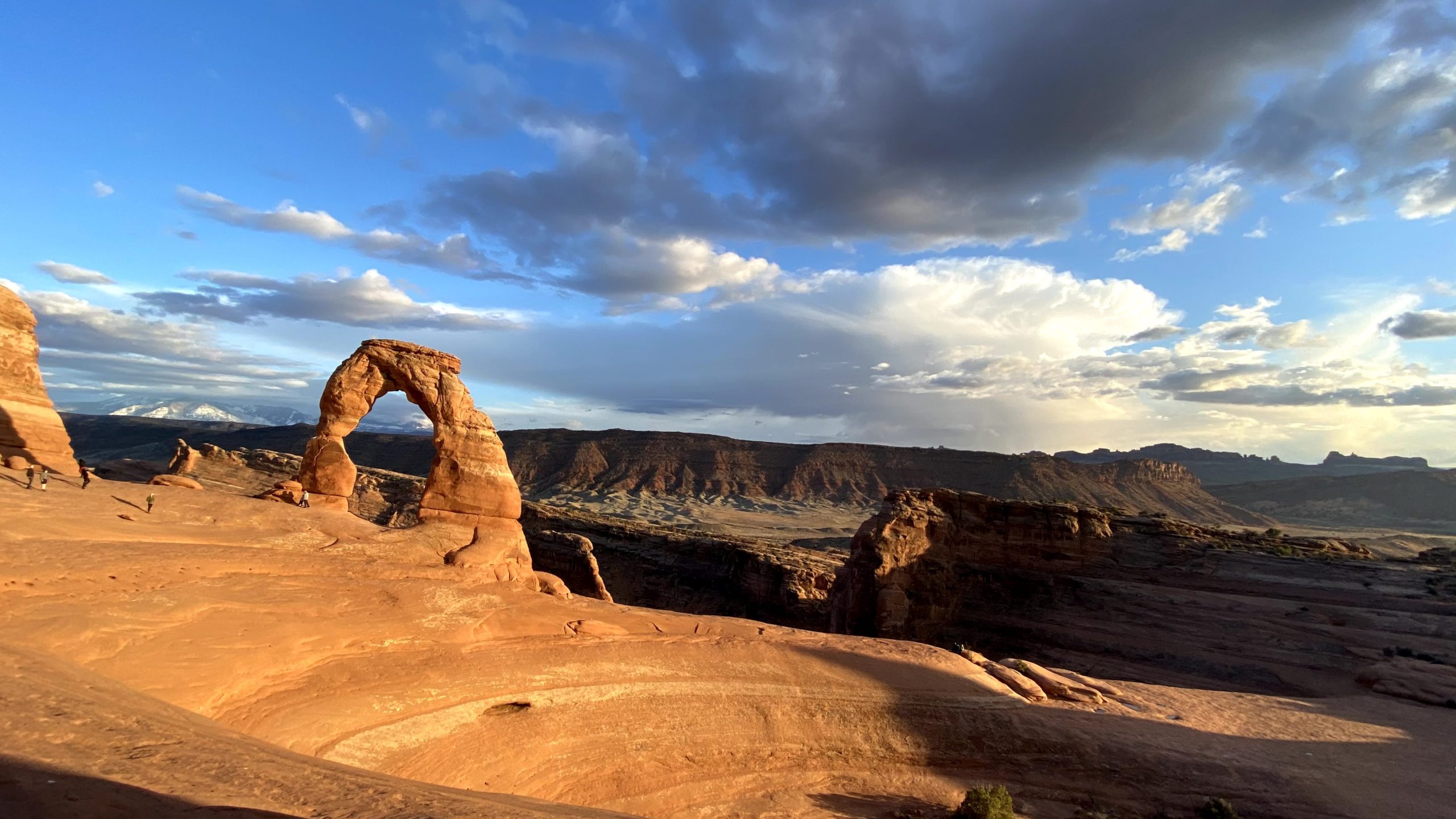
I had a few options planned out as possibilities for sunset, but in the end decided to catch the iconic Delicate Arch sunset. Delicate Arch is the rock formation on the Utah license plate and probably the most famous arch there is. Sunset is very popular for photographers. I debated going for sunrise or sunset. The appeal of sunrise would be to beat the crowds, but sunset would allow me to avoid doing the hike in the dark and see the iconic arch lit up. I decided to do sunset!
I drove the thirty minutes from Moab to Delicate Arch trailhead. It is a steep, windy drive that I found a bit scary until it flattened out, but would get used to as I drove in and out of the park several times throughout the weekend.
Delicate Arch is quite an uphill trek. It’s only 1.5 miles up, but it seemed long. It’s a beautiful hike though as you gain elevation and can see more of the park. I found that way, way, more people were coming down than heading up for the famous sunset. I think the busiest part of day at Delicate Arch is midday, so either sunrise or sunset are both good bets to avoid crowds. It is easy to space out though particularly hiking up and down the large portion of steep slick rock.
As I reached the top, there was a point with a drop off that challenged my fear of heights, but I stayed looking at my feet (it didn’t seem so bad on the way back for some reason).
Delicate Arch is in this huge, steep bowl. That was probably what surprised me most is how un-flat it is, and I found it a bit scary to be honest. I saw a girl drop an AirPod and it started to slide down the bowl until someone grabbed it. Later, I dropped my phone on the rock and quickly grabbed it while sitting after the sunset, and a guy sitting near me told me last time he was here, a woman had dropped her phone and he hiked all the way down to the bottom to get it (it’s really far!). Then, she put it in her pocket and it FELL AGAIN. She had a hole in her pocket. He does not know what happened after that (oh. my.).
Anyways, I did not really enjoy walking close to the arch and decided to skip waiting in line to take a photo under the arch, and instead pick a sunset viewing spot. I found a flat rock close to the trail and set up there.
It was super windy which made it feel really cold. I brought my backpacking stove and some food thinking I might make a quick dinner but skipped that idea and just had the beer.
Sunset was at 7:36 that night, and at 7:04, the arch lit up with its bright, orange color, the snow-covered mountains shining behind. The glow was over by 7:18. It was short-lived but magical, and I think well worth the journey and wind.
I headed down after the glow ended to avoid hiking in the dark too much, and enjoyed sunset colors as I reached my car around dark (tip: bring a headlamp for all sunset hikes – I only had to use mine at the very end).
I got back into town and felt much warmer without wind blowing. I found restaurants were still open in town, so I went to the very cute restaurant Spoke on Center and got a burger on their patio before heading back to my campsite. It was pretty cold by this time, so I snuggled up in my tent so I could be up for the sunrise the next morning. I had considered trying Delicate Arch for both sunset and sunrise, but after a fairly tough hike up, quickly ditched that idea. Read my next entry to find out where I decided to head for sunrise!
Nick and I have been dealing with our radiator being down for over a month and a temporary heater. After a recent big snowstorm, we were tired of the cold and snow. I had stumbled across this Denver Post article and once we looked at the forecast for Pueblo (70s), we were sold on the trip.
Saturday, March 20
Nick and I hit the road and decide to check out the Royal Gorge via the Overlook Trail. It’s an easy, 1.5 mile trail with amazing Royal Gorge overlook and snow capped peak views that are hard to capture in photos. It was a beautiful day and felt so nice to be warm. There is a lot more you can do at the Royal Gorge and we saw (and heard) people ziplining or taking the gondola over the gorge. There is also a train that runs through the Gorge that looks amazing. I definitely would love to visit again and ride the train.
After Royal Gorge, we headed to Legatum Cellars. There are several wineries in the Canon City/Penrose area. We were met with extremely kind staff and a beautiful outdoor setting, as well as live music. They had a free tasting and we got to chat with the winemakers. The bottles of wine were extremely reasonably priced so we left with one.
Next, we headed to Brush Hollow Winery in Penrose and sat out on their beautiful patio, where we were the only people outside enjoying the mountain views and beautiful weather. They had an extensive free tasting with purchase that included ciders and a dessert wine. We also got a beautiful charcuterie board. We got to speak with the winemakers there as well and left with a wine bottle and growler of cider.
I continue to really enjoy Colorado wineries. They are completely unpretentious, well priced, in beautiful locations, and have great unique products. Often they are family-run or tight knit and you speak with the winemakers. One thing we learned is that a big freeze killed a lot of Colorado grape plants, so sourcing local grapes will be a struggle for the next several years. Plus, fires in Palisade and California will make grape sourcing challenging. See this article for more information. Ways to help:Sign up for CSAs or Growhaus, which I use. Plan a road trip to Colorado’s fruit-growing regions and buy directly from them; see my Paonia Orchard and Wineries and Palisade Winery Bike Tour posts for ideas.
We headed to Pueblo next, where I had a free Marriott stay. We walked to the Riverwalk, which is a beautiful area to walk around with restaurants and bars. One restaurant had some excellent live music.
All the restaurants had a long wait, so we enjoyed drinks at a bar overlooking the river before deciding to order takeout sushi and sit at one of the many tables around the river. After that, we headed to The Clink Lounge for a fancy cocktail. This hotel and bar is in a former jail. The patio was lovely and the cocktails were so good.
After that, the one must-do I had on my list after reading the Denver Post article was to visit Neon Alley. We walked through the quiet historic downtown and then came upon the first lights. This is a collection of vintage neon signs turned public art installation, and it is so much fun to see.
We heard people commenting that there were new signs since their last visit, and I have read that the collectors keep adding more signs. There are also some really fun vintage posters in the alley. If you go, be careful because it is definitely a real alley that cars drive through.
This was a long day so we headed back to relax in the hotel room for the night.
Sunday, March 21
The next morning, the weather appeared nice, sunny, and 55, but it was quite windy out. We headed over to B Street Cafe. It was nice enough to sit outside this diner-style restaurant and we enjoyed an awesome breakfast across from the historic train station. There are a lot of preserved historic buildings in Pueblo that we enjoyed check out downtown before heading to the car. We stopped at Solar Roast Coffee before heading out, as the wind continued to pick up.
Overall, this was a really fun, mostly warm weekend. It is an underrated part of Colorado, in my opinion, and I really enjoyed how friendly everyone was and it was not as overcrowded as some other areas of Colorado. Spring is a really tough time in the Front Range of Colorado, when we are all getting tired of snow and mud season makes hiking unpleasant and/or impossible. I think we will definitely repeat this trip in future years around this time of year.
From January 4-6, Nick and I stayed in rustic cabins at the North Michigan Reservoir at State Forest State Park in Colorado. This is a gorgeous part of the state, near Walden and the Rawah Wilderness and Medicine Bow Mountains. Nick had a month off for winter break, and has a busy year ahead in his compressed grad school year, so a few days off in a socially distanced trip sounded nice.
This was not my first time at the cabins; in May 2019, I joined a Meetup group of strangers who stayed in the 20-person cabin that is available at the Reservoir. It was a great time, very snowy even in May, and struck me as a great, fairly isolated place for a getaway, so I thought of it when we were thinking of doing a January trip.
Day 1
Nick and I headed out January 4, stopping for a nice hearty breakfast on the Snooze patio in Fort Collins, which is only an hour away from Denver. I find if the sun is on you, sitting outside is lovely even if it is fairly cold. We then drove 2 hours through Poudre Canyon on Highway 14 to get to State Forest State Park. This was our first time driving in this area since the Cameron Peak Fire, which truly was a devastating fire this summer. We saw burned trees and scorched land, and it was honestly amazing how many structures and houses in the area were saved in these area. Firefighters did an amazing job, and we saw lots of signs thanking them. By the way, the Roosevelt National Forest in this area was still closed when we were there, so it’s important to check for closures before you head out to different recreational areas.
The drive is gorgeous along the Poudre River, which was flowing but icy and snow-covered. Then, as we approached State Forest State Park, there started to be truly stunning scenery of the mountains. Because the weather was scheduled to be sunny and the warmest of our days there (in the 30s!), we decided to stop along the way to hike and snowshoe on the Lake Agnes Trail.
We chose the trail from our snowshoeing book. It is 5 miles in winter; you park in a parking area along the road, which is closed to cars, and hike along the road. We didn’t need our snowshoes for this (spikes only), and walked along the road uphill; the views are stunning from the get go of the mountains and the Nokhu Crags, this fantastical rock formation. After a little over a mile you reach the summer trailhead, which has a historic cabin ruin and opens up to stunning views.
At this point, we needed snowshoes (or skis, we saw some skiiers as well!) as the snow was deep. We had to work on our snowshoeing uphill skills.
After another mile or so, we made it to the lake which is just stunning. It is frozen and the Nokhu Crags and in full view. Nick and I particularly enjoyed this hike because when we did our American Lakes backpacking trip over the summer, we were right on the other side of the Nokhu Crags at Snow Lake. Now we have seen both sides! It was lovely and sunny out so we took a brief snack break before heading back.
The timing worked out well to get to our cabin around 4 pm. There is a good, snowy dirt road leading to the cabins. The notes for the cabin suggested we might need snowshoes for the 100 feet from the parking down, but we didn’t when we arrived. We appeared to be the only ones staying at the cabins, and it was quiet and beautiful in the late afternoon.
Check in was easy as we just had to use a code to get into the cabin (no human interaction!), and unload our stuff. The cabin has propane heat, a table, bunk beds, and cozy futon type couch. It has a solar light and no electricity, and there is no cell reception. After we unpacked, we chilled our beers outside in the snow and attempted to make a fire in the grill, but it would not catch. We brought our backpacking stove and simple dehydrated meals along with some snacks to keep the cooking easy since the cabin does not provide a kitchen. We even roasted some marshmallows with the backpacking stove for s’mores.
We watched a gorgeous sunset and settled in for an evening of reading and games. It was truly peaceful, quiet, and relaxing. The three cabins share a basic composting toilet bathroom, so we did have to trek through the snow for the bathroom.
Day 2
The forecast had a small chance for snow on Tuesday with an inch, at most, expected. We woke up to try to watch a sunrise and it was snowy.
We had a lovely breakfast with hot coffee and spent most of the day reading and playing games inside our cozy cabin. It stopped snowing briefly and we saw some sun, but it just kept going. It ended up snowing a lot of the day! To go to the bathroom, I started strapping on my snowshoes, along with my gaiters and boots. The snow was getting really deep!
We got some pictures in the afternoon when the snow stopped briefly. We decided to bundle up in every layer including rain gear and snowshoe around outside our cabin on the frozen reservoir.
It turned out to be good timing because the snow continued into the evening. We really enjoyed having a peaceful, snowed in day.
Day 3
The next morning, we actually did see more of a sunrise and awoke to a sunny, but frigid, day. Temperatures were not supposed to get above freezing all day and it was cold, but felt better with sun!
After a nice hot breakfast, we decided to head out for a snowshoe right down the road. The road we drove in on continued to some winter trailheads for yurts, also available to stay at in winter. Our snowshoeing book suggested the yurt trails for outings.
We got to enjoy snowshoeing in perfect, sparkling fresh snow and even started to warm up in the sun. The mountain views from the road were beautiful. We did see a few cars parked for the yurts, and were passed by a few cars on the road. Apparently others were excited by the fresh snow and beautiful day and excited to get out for some backcountry skiing or snowshoeing. After about 1.5 miles roundtrip, we were back at the cabins and other cars had joined ours. We some guys headed down to the reservoir for ice fishing.
We packed up our cabin and snowshoed up to the car with our belongings. We swept up and enjoyed last views. With all the snow, we put Autosocks on my front wheels, which is a chain alternative. They worked well to help us get out on the snowy dirt road (by now there was also a family getting ready to ski/sled/snowshoe in the lot as well!).
We had a beautiful, different drive back, with everything covered in snow. We got some last looks at the Nokhu Crags, majestic as ever in the sun. It was odd as we got closer to Fort Collins, there was less and suddenly no snow. Very strange after all the snow we had gotten at the cabin!
We ended the trip with a meal outside a distillery in Fort Collins, with a lovely firepit to keep us warm. And, we even grabbed some ice cream at Old Town Churn. With the sun and another fire pit, it felt like a perfect ending to the trip.
Overall, I highly recommend these cabins for a getaway! They are rustic but a perfect pandemic era getaway.
Here is some recommended gear for a trip like this. These are affiliate links which allow me to collect a small amount of money for items bought, but I only link items I like and use.
Kahtoola Microspikes – Nick and I both have these traction devices – they easily slip on and off your boots for traction on ice while hiking.
Black Diamond Gaiters – These are the gaiters I have. They prevent snow from getting inside your boot when hiking and snowshoeing in deep snow. A genius little invention!
CMC Snowshoeing Book – Colorado Mountain Club’s snowshoeing book. I love how detailed this book is in describing snowshoeing trails!
I woke up and enjoyed a nice sunrise out my window on Saturday, October 18. I decided to get a hearty green chile breakfast burrito to go at the cafe next door, which I ate before heading on my solo adventure to Colorado National Monument, after my Paonia and Palisade adventures. The Monument is only 10 minutes from downtown Grand Junction, which makes it easy to get an early start.
Colorado National Monument has a 23-mile scenic drive. Starting at the Grand Junction side, I identified a couple of hikes I wanted to try in the morning before I completed the drive, where I would end up camping near the Fruita entrance.
I decided to try Devil’s Kitchen Trail first, which is .75 miles one way as the sign says (1.5 round trip). It was a beautiful morning and I was surprised to see some nice fall colors alongside the prickly pear cacti on the trail.
The trail was really beautiful but got confusing with a lot of “social trails” as I got closer to the rock formations. I tried to take it to the end, assuming I’d end up at the “Devil’s Kitchen” formation, but the trail kind of petered out. Anyways, I found a place to easily walk up to the rocks (no crazy scrambling/stepping on prickly pears required!) to get a closer look.
It was not very busy and I spent some time enjoying the rocks and taking pictures before heading back to my car for a snack and sunscreen application.
I wanted to do more hiking so I chose the nearby Serpent’s Trail, 1.75 miles (3.5 roundtrip). This is an old road once called the “crookedest road in the world” with 20 switchbacks that was converted to a hiking trail. This means it is flat and wide. You start climbing right away and quickly get great views of the scenic road and the trail.
I completed the whole trail with great views all the way up. It just kind of ends at another part of the road. I would definitely do it again, but even just the first mile up and back down would be worth it for the views.
It really started to warm up in the sun. The weather was really perfect, getting into the 60s and 70s. I think it’s a nice time of year to come- summer would be hot! Plus the fall colors contrasted with the rocks is gorgeous. I decided I was done with hiking, having done it during the coolest part of the day to warm up, and was ready to scenic drive to my campsite in the afternoon.
The scenic drive is a bit scary for those of us with a fear of heights, so I focused on my music, the road straight in front of me only sometimes, and stopped at nearly every stop to break up the drive and check out the views. It requires full attention as it’s popular with bikers as well. It’s definitely a must do if you visit! It reminds me a bit of Black Canyon of the Gunnison, which has various stops – some are viewpoints, some are short hikes, and some are trailheads for longer hikes.
“The heart of the world,” is what a man some called an eccentric drifter, John Otto, said about this place. He built trails on his own from 1907-1930s, and then the Civilian Conservation Corps built Rim Rock drive mostly by hand, which is truly remarkable.
One of my favorite moments of the afternoon was on Otto’s Trail, a very short trail to a lookout. There was only one other group, and they left, and I was able to have the place to myself. I sat for a while. The canyon is odd, and you can hear far away voices almost like they are near – that’s how I first realized there were climbers on Independence Monument, and spotted them far away (it’s the big rock formation on the left side in the picture below). John Otto was the first to climb this, of course, and climbers still use Otto’s Route. They continue his tradition of planting an American flag at the top every July 4th.
I enjoyed my meditative silence for a while, but was getting tired after a long day of hiking, driving, and exploring. Luckily, I was almost to Saddlehorn Campground. This is the only campsite within the monument, organized into three loops.
The campsite is really cool! The ground is hard so I used rocks for my tent (it was windy so I flied it out with rocks, Iceland style!). I got in some good reading time at my chair and made an early backpacking meal dinner.
I wanted to check out the sunset, and a viewpoint called Book Cliffs view was only a ten minute walk away. It’s an amazing place – there are trails leading to Window Rock and the Visitor’s center, and it’s easy to find some rocks to hang out on. I had grabbed a Big B’s Cider from my Paonia day, and had a peaceful happy hour watching the sun go down.
It’s fascinating to see how different everything looks in different light, and watch the birds, and listen for animal and people noises.
I headed back to camp and had my hot chocolate, did some more reading, and settled into my tent after checking out the stars. Despite the rocky ground, I slept very deeply. It did not even get too cold at night (my guess is 40s?), so I was very comfortable with my gear.
I set an alarm to ensure I did not miss the sunrise, and I had a plan. Why not head back to the same spot where I watched sunset to watch the sunrise? And, since I had a backpacking stove, I could make my coffee and oatmeal there.
As you can see from this unfiltered photo, the sunrise was gorgeous.
I decided once I was done with coffee to warm up more by hiking from Book Cliffs viewpoint over to Window Rock, a short distance.
After that, it was a short walk back to my campsite. It was nice out, so I enjoyed sitting and reading a bit more before packing up camp. I had a few more stops on the scenic drive on the way to Fruita.
As I was leaving the last stop, I realized I would get to Fruita a bit early for lunch as it was around 10 am. I saw there was a state park right near where I was, called James R Robb Colorado River State Park. They turned out to have a really nice sidewalk by the river perfect for a quick bike ride, with fall color and the Colorado National Monument in the background. I unfolded my bike and enjoyed a quick two miles.
My last stop before heading home Monday was Fruita, which has a nice small downtown. I had to put in a picture of my insane meal from Kamilla’s Kaffe, which had a lovely patio. I grabbed some coffee to go from an awesome place called Bestslope with a walk up window.
Overall, I loved camping at the monument. I definitely recommend the fall for a visit, as the weather was perfect, and hiking in the morning to beat the heat.
Covid-19 Safety: Overall, this section of my trip was very pandemic friendly. I was outside nearly the entire time with a lot of spacing on mostly wide trails, and saw a large amount of people with masks. I skipped a few viewpoints that had full parking lots, but had plenty of others to check out! Camping required no check in as I had reserved the site and the shared bathroom had its door open the whole time.
Saturday was Day 2 of my solo Western Colorado trip. After my tour around Paonia, I woke up to a beautiful sunrise in the orchard. I packed up my tent early and stopped in Hotchkiss, Colorado, at the Coaltrain Coffeehouse, a very cute independent coffee shop. It was about an hour drive to Palisade, which turned to a much different rocky scenery (kind of like Paint Mines in Eastern Colorado).
I headed to Riverbend Park, since it was fairly early still. I have a foldable bike that I can fold up and put in my car. I got that out and tried out the flat bike/walking path along the Colorado River. Technically you can bike all the way to Grand Junction! The views are amazing and unique in Palisade with the rock formations, and I still saw some beautiful fall colors.
Next I checked out the town to find some food. The town is small but really nice, with a number of restaurants and cafes. I stopped at a funky cafe called Purple Cow and enjoyed sitting outside. After this, I was ready to start an afternoon of self guided bike winery touring!
I looked at a map online and decided on the West Cruiser Loop, which is 7 miles and passes a lot of wineries and nice scenery. I cruised back through Riverbend Park on this route. The great thing about the loop is that it passes a lot of places, so you have flexibility if somewhere looks busy to simply move on.
Safety Notes: I want to note that I wore a helmet, and a small part of the route was on a busy road, so please be sure to know basic bicycle safety if you choose to do this. I will also note that I wanted to be careful with my drinking amounts since I was biking and then driving to Grand Junction after, so drank slowly at each stop to enjoy my time, only got tasting portions and no glasses, and had my hydration bladder full of water (and each winery provided water as well!).
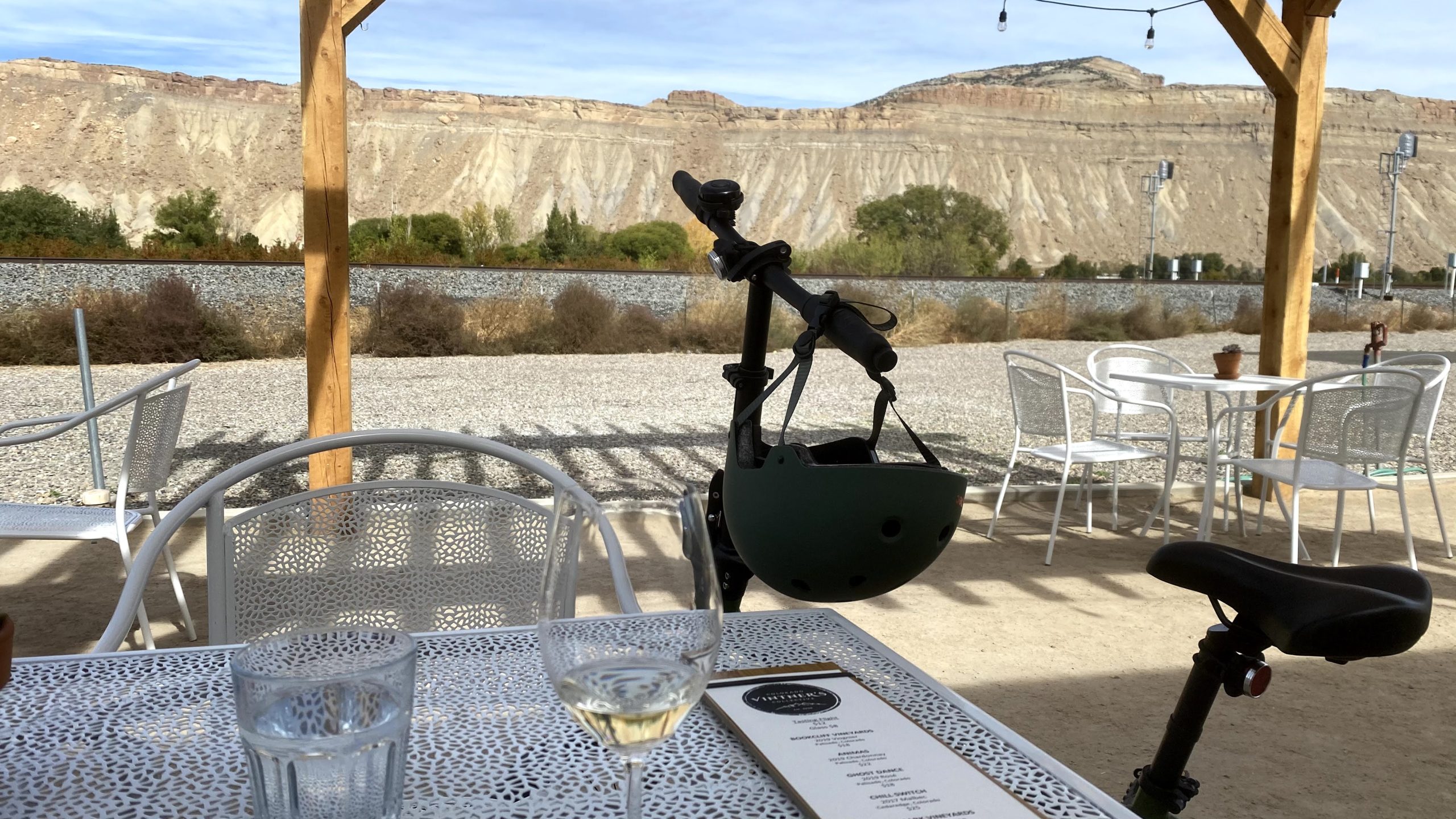
My first stop was Colorado Vintner’s Collective, a clean modern space with a lovely patio. I did a tasting, which included wines from local wineries as well as some of the Collective’s wine. It was really lovely – once again, I found my host to be extremely nice and friendly in explaining the wine to me. I absolutely loved the rose made by the Collective, and so I decided to put a bottle in my backpack to bike around with on the rest of the Loop (shows you how much I liked it!).
In my research, I really wanted to check Maison La Belle Vie. It was a French themed winery that had an excellent patio, according to information online. This location was busy and only got busier as I was there, but the patio was really lovely with great views of the winery and rocks. Their tastings were pre-selected and came with guide cards, which was nice. They had beautiful charcuterie boards for 2-4 people, but since I was solo, I went with a delicious quiche and salad.
After Maison La Belle Vie, I biked the loop and passed wineries and orchards. I really enjoyed the beautiful scenery and awesome sunny weather.
I came upon an area with Grand River and Talon Vineyard, but it was quite busy so I decided to skip tastings. It seemed nice and they had horse drawn carriage rides there apparently!
Next, I stopped at a fruit stand. They were out of peaches, and I already had apples, but I decided to take advantage of their end-of-season sale and buy some jam. Nick and I have been enjoying the Apple Pie Jam from the stand.
Next, I decided to go slightly off the loop to try one last winery, Varaison. This was an excellent decision, as it turned out. Their tasting is free and includes wine education with a person assigned to your group. Since I was solo, I was one on one. The woman who guided me through the tasting was very friendly, wore a mask, and we sat outside at a table across from each other. She was also from Arizona, as it turned out. It was very informative, and I decided to get one more bottle of wine. Total, from the trip, including Paonia, I brought home three bottles of wines I tried to share with Nick.
Covid-19 Safety Notes: The bike tour of wineries is extremely pandemic friendly. Wineries have excellent patios, and it’s easy to bike and check out to see the space and whether you feel comfortable to choose which wineries to check out. And biking outside is lovely. All the servers and staff wore masks and people were good about mask wearing when not at their tables. While this area of Colorado is busy and has tourists, it is also less packed then other tourist areas, in my experience.
I was staying in Grand Junction, so I finished my bike ride and drove about 15 minutes to my hotel, a SpringHill Suites (I had a free night certificate). I was apprehensive about staying in a hotel during a pandemic, and enjoy camping experiences, but the hotel did an excellent job with social distancing, one person in an elevator at a time, and mask requirements. They even encouraged you to bring your bike to your room to avoid theft (not a Covid related item but nice). I spent fairly little time at the hotel, as well.
I walked around downtown Grand Junction, which was full of fall color. There were several good options for dining with nice patios, and I ended up at a brewery. I also grabbed gelato to go.
My room had a really nice sunset view. I wanted to get started early the next day to maximize my time at Colorado National Monument, which will be my next blog entry!
Gear Recommendations
This part of my post contains affiliate links that allow me to earn a small commission at no extra charge to yourself. I’m genuinely posting items I use and believe are helpful for this type of adventure!
Foldable Bike: I have the Retrospec bike, but as that often sells out, here is a nearly identical alternative that you can throw in your car for flat bike rides – like the West Cruiser Loop on the Palisade Fruit and Wine Byway, or the Riverbend Park trail!
Hydration Bladder: I recommend this and your favorite hydration-compatible backpack to ensure you stay hydrated during a wine bike tour.
I had a long weekend October 16-19, with Monday off work as a required furlough day, so I decided to head to Western Colorado. It was my first solo trip in a while, since Nick had to study for midterms. It seemed like a nice time of year to head out to the area, which is warmer than the Denver area this time of year. For the first day, I decided to drive to Paonia, Colorado. I had heard this was a cool area, but found that you could camp in an orchard, which sounded like a fun way to spend a night of the trip.
I did the typical drive from Denver, heading west on I-70; however, I had yet to drive through Glenwood Canyon since fires earlier this year. I could definitely see some burned landscape, but it was really beautiful as there were a lot of fall colors near the rushing river. Then, I turned onto 133 to get to Paonia, which was all new driving for me. The landscape was really beautiful, with lots of golden fall colors and a river.
It’s a bit over a four drive, but it was lovely, and I made it to the small, cute town of Paonia. I walked around a bit and considered doing lunch there, but I had spotted a few wineries on the way in and wanted to visit those – there was one that had a market as well for food.
I decided to head back to a winery I had spotted on the way to Paonia, just a few minutes away. Blackbridge Winery was down a road next to a river. It was cute as soon as I arrived and they had a lot more than wine – there was a whole pumpkin patch outside! They also had a market with lots of local products from honey to pasta to local art.
I wanted to do a wine tasting. I found the couple running the wine tasting super nice and down to earth, and my tasting included 5 wines which I could choose and the glass below. They had a variety of red and white wines including a Peach wine that was not very sweet but dry, which is nice! Palisade especially in this area of Colorado is known for producing peaches. I grabbed a bottle of their Alpine White, which was on sale.
Black Bridge Winery has an amazing setting along a river, which was stunning this time of year with fall leaves, mountain views, vineyards, and 60s-70s sunny temperatures. They invite you to picnic with a bottle of wine along the river, and have some picnic tables and chairs set up – you can even buy some nice cheeses and snacks inside. It’s definitely a place I want to return to! You could spend several hours JUST here.
But, I did want to check out some other wineries too. Next, I headed to a spot I’d seen right near the road – Qutori Winery/Root and Vine Market.
There was a patio with a just gorgeous view of the vineyards across the way, where many of the wines are made from. I tasted a few and settled on a lovely rose and a croissant sandwich from the market. The people were once again very nice. There was a lovely watercolor mural in the winery tasting area (inside but open air) that the woman told me the owner and her son had completed themselves. This was a lovely, peaceful setting to enjoy lunch. There was another solo person at a table nearby, and we started chatting. He could work remotely so had moved to the area and loved it. It was fun to travel solo and be able to make a socially distant friend! I told him I wanted to head up to Azura Winery next, and he said that had the best views. He was not wrong as you will see!
Azura has a Mediterranean feel to it. You drive up a mountain a bit to these beautiful buildings, which include a small art gallery. The tasting was all outside, and then the seating was outside overlooking just a gorgeous view. Once again, the woman doing the tasting was very nice and invited me to check out the art gallery (which was empty of people) and the lake for the “yacht club,” in which its members use small remote control boats. I ended up with a glass of the “Yacht Club Red.”
The views here were truly stunning. My last stop, the camping spot at Big B’s Orchard, was only a five minute drive away. I wanted to pace myself in enjoying the wine (and ensure I was drinking lots of water!), so I sat for a while and listened to a podcast (I got no cell phone reception here), and enjoyed the view.
Big B’s Orchard is a really fun, unique place that’s also a cidery. There is a store, cafe, and huge outdoor area with tables and swings. It was still lovely late in the afternoon. The store has all kinds of produce and goods! I got apples and some cherry tart cider to go (all excellent). I also ate a delicious pulled pork sandwich and enjoyed the outdoor area.
I then walked around the orchard a bit and enjoyed some fall colors and nice views before heading to my campsite, right in a row of the orchard.
I really enjoyed the simple campsite – I had a picnic table and set up my chair and tent. There were campers in other orchard rows, so I felt safe and not alone, but also had some privacy in my little area. I read for a bit, but sunset is early these days – 6:30 pm! It’s very different from backpacking where I often was tired and just waiting for the sun to go down at 9 pm.
I feel asleep quickly, but woke up around 10 pm and then saw the most amazing stars I’ve ever seen – I didn’t really get a great capture on my phone, but it was stunning! Overall, it was a fun campsite, and I’d love to spend more time at Big B’s in the future.
Covid-19 Notes: Overall, the places I went were very naturally set up for pandemic safety. I wore a mask whenever I wasn’t seated eating, and everyone else did as well. There were all outdoor seating areas, and even areas technically “indoors” had a large garage door or door opening to allow for air flow. The camping check in was in the store, which had open doors for air flow, and was quick. My campsite was very spaced from others so that I enjoyed privacy.
My next blog post will cover heading from Paonia to Palisade for a winery bike tour.
Over the fourth of July holiday this year, Nick and I decided to head out to the Telluride/Ouray area of Colorado, six hours away. I did not think it would feasible to do much of anything when the pandemic hit, so I was excited we were able to take this road trip. We decided we would keep it safe by doing only dispersed and backcountry camping, in which there are no facilities. We had a fun drive out on Wednesday, July 8, stopping in fun places like Buena Vista and Salida along the way. Our goal was to get to a dispersed camping spot near the trailhead of Blue Lakes in the Mount Sneffels Wilderness so that we could begin a backpacking trip there the next day. I had somehow seen this hike and marked it as something I wanted to do as soon as I saw the pictures, but knew it would be a long drive. I was so excited when I realized we could actually do it.
We drove down a rocky road and wondered if there even was a dispersed camping site, but enjoyed gorgeous scenery with 14er Mount Sneffels in the background. When we got to the site, we were amazed at how stunning it was.
The weather was so clear that we were actually able to have our tent in stargazer mode. Whenever we woke up, we saw tons of stars. I also started testing out the night mode on my camera phone.
The next day, we got up at sunrise to beat the crowds and headed to the nearby trailhead. We strapped on our packs and started a steep, uphill climb. It was gorgeous and peaceful, but started to fill with people. We saw a solo backpacker coming down who told us about an amazing camping spot that we would end up taking. The trail up was tough with lots of stops, but it did start to flatten out a bit towards the end which was nice. It was 3 miles to the lower blue lake.
It was definitely worth all the work as we came upon the lake in the morning light. It is truly stunning. I have not altered my photos a bit to get this blue color.
We were there early enough that there were a lot of backpackers still with tents up from the previous night. Based on the advice from the kind backpacker, we snagged this spot:
Truly unreal. Our spot was far from other backpackers and was like our own little paradise, and still far enough from the lake (100 feet away) to be within regulation. The sky was perfectly blue with no sign of a Colorado monsoon. It was so early that once we set up camp, we had our coffee by the lake.
Next, we wanted to do a day hike to the upper lakes. It’s another mile to the upper blue lakes. It was a relief to just have our light daypacks as we headed up the steep path. Fueled by our morning coffee, we got stunning views of the lake below.
It was a tough hike up and the landscape turned rocky, with pikas and marmots scurrying past. Nick and I stopped for a snack break at the first upper lake, which was just as blue as the lower lake.
As you can see, the scenery was truly gorgeous. It felt like being in Lord of the Rings, or Iceland, or Scotland. We took the path to the second lake. It’s not as scary as it looks here! There were also a ton of wildflowers along the way.
We had lunch next to the upper lake. We watched people hike up the steep path to summit Mount Sneffels. Many people camp at Blue Lakes and then tackle the peak the next day. It requires some technical rock scrambling to get to the peak, but apparently, you can see all 3 lakes from the top.
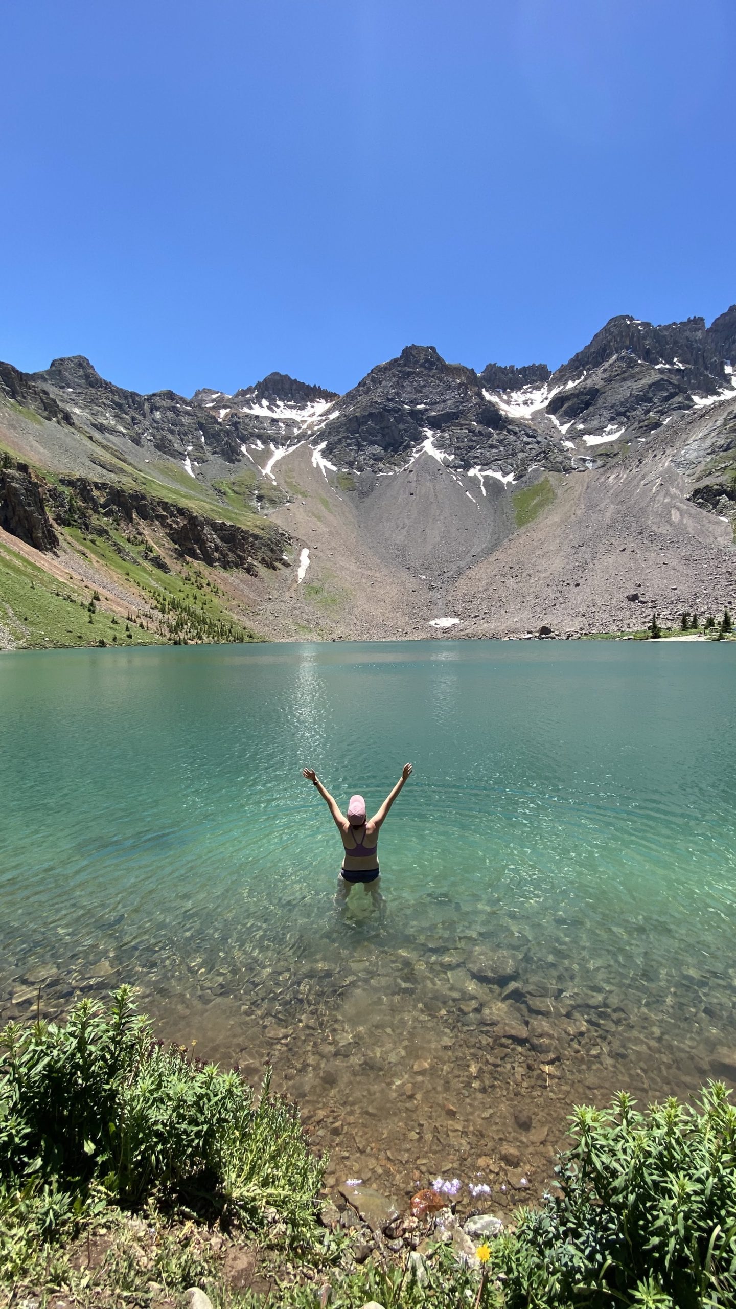
We were ready to get back to our camp to relax for the rest of the day. We hiked down and it was pretty warm at this point. We decided to try getting in the lake, although I struggled to get past my waist deep due to the cold. It definitely felt amazing, and in the sun, you dry quickly. People swim, kayak, and fish in the lakes!
Nick and I settled into our favorite afternoon backpacking activity; reading and hammocking. And you can’t beat these backpacking views. The skies remained totally clear (the lack of rain was bad for Colorado’s fire season but made for good backpacking). It felt extremely peaceful despite the fact that this is a popular hiking and backpacking spot.
We ate dinner by the lake and watched the sun go down. We again were able to leave our tent in stargazer mode (no rain fly) and had the view below.
The next morning, because our tent fly was off, I saw a silent fox scurry through our campsite. We woke early to make breakfast by the lake. We decided to watch the sun come up over the mountains and the lake. It is amazing how different it looks as light hits it differently throughout the day.
We actually spent a perfect 24 hours with the lake, as we had arrived around 8 am the previous day and left around the same time.
It was definitely hard to say goodbye to the lake, but now that it was Friday, we wanted to beat the crowds, so headed out. We saw a ton of backpackers coming up as we left, along with day hikers, so I was glad we were able to do a midweek trip. We passed on our camping spot location to another friendly couple – hope they found it!
We headed to Ouray, a delightful mountain town, for food and drinks, and Black Canyon of the Gunnison as well, before finishing out the night in Salida and finding another dispersed camping spot. These are all places we loved and want to go back to.
Overall, this part of Colorado in the San Juan Mountains is absolutely beautiful. This was a trip we will definitely remember for a lifetime. We would definitely love to repeat it, but we have so many things in our list! Also in this area are Ice and Island Lakes, which are similarly stunning apparently.