I had a fourth of July holiday combined with a flex day combined with a furlough day that gave me five days off, and since my boyfriend Nick has not started his grad school yet, we decided to do a multiday backpacking trip. Nick made a YouTube video:
Day 1 – Goose Creek Trail 612
I had done this trail as my first solo backpacking overnight in 2019, so I was excited to go back and knew what to expect. We left early and drove a lot of dirt road to arrive at the trail head. This trail starts looking over fire damage from the 2002 Hayman Fire that burned for a month.

There were lots of wildflowers the entire hike! We descended into a shady forest along the creek, and had some uphill to gain before the campsite. I hoped to go to the creekside campsite I’d gone to the previous year, about 5 miles in.
Along the hike, we started to see distantly the giant, weird rock formations of the Lost Creek Wilderness.
There a short, worthwhile detours where we put down our packs to explore historic cabin ruins. According to the sign, the Lost Park Reservoir site between 1890 and 1913 attempted to create a reservoir damming lost creek, and these cabins were employee housing hand when from native trees. There’s even remains of beds/mattress/oven. It’s amazing!

After a some uphill hiking…

We got to our campsite fairly early (My campsite was free!) and were excited to hammock and read books all afternoon.

This was a great first day – no rain all afternoon. We were definitely tired and ready to rest and relax, with the nice trickle of the creek. It was surprisingly not very busy – we only saw a few people pass our camp on the trail. To me, it was a bit exciting and nerve wracking to find out what was next, as the next day we would get into a lot harder elevation gains and new territory.
Day 2 – Goose Creek to McCurdy Park
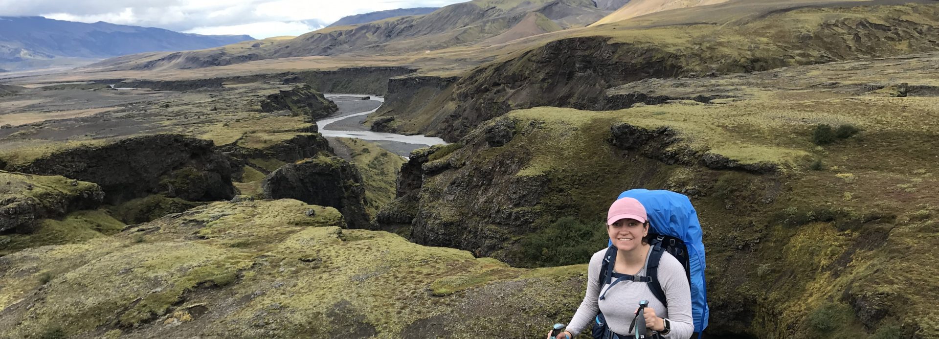
The next day was our most challenging day that at times made us ask WHY DOES ANYONE DO THIS. We got about 11.7 miles into the loop this day – so did around 6.7 or so miles. There was an incredible variation in landscape this day and steep up and downs. Supposedly we only gained about 1000 feet, but my GPS app measured 2500 between the ups and downs.
When I came in 2019, I’d gone on a bit up Goose Creek. It continues uphill through beautiful forest, which was gorgeous and quiet in the early morning.

Eventually it opens up to a beautiful viewpoint, which shows you how far up you have come.

We then turned onto the McCurdy Park trail, which was steep downhill.

This was a bit ominous – we knew we had more uphill to go. We descended into a beautiful aspen forest. The way that the sun glows through the aspen is quite magical.

We then had to go up and up and had huge rock formations ahead. It was hot, and challenging. We had a couple of steep up and downs among the red rocks.

At one point, we descended to a cave with the river flowing through, and a really cool campsite right there. We almost got lost, but our handy paper map plus GPS on phones helped. We stopped for lunch in the shade before pressing on.

It was hot, with more steep ups and downs. We ran out of water, but descended into an aspen valley near a creek and refilled with our water filter. We really wanted to make it to a meadow we had read about with good camping.

The last part was challenging. Some clouds, but a storm didn’t really roll through. We had an uphill portion in a forest that seemed endless, and everything hurt. We stopped a few times and made slow progress.

We looked so close to the meadow on the map, but it took forever. Finally, we reached the clearing and found some campsites in a beautiful meadow next to the creek.

It started to thunder so we set up our tent quick and waited out some thunder inside. It was already late afternoon. We were starving so we made our freeze-dried dinners. That chicken fried rice was the most delicious meal ever. However, the mosquitoes were horrible. We covered every part of our body and put our buffs over our faces, and devised a method of walking and eating to keep the mosquitoes at bay.

We split a cup of hot chocolate inside the tent. Of course, the mosquitoes started to die down as it got cold.
Several other tents joined the meadow – according to the paper map we had, it’s exactly halfway so a good campsite for people doing the trail as an overnight. We were all at least 200 feet apart though.
Day 3 – McCurdy Park to Lake Park to Hankins Pass
We woke up first to a beautiful sunrise, and walked across the meadow to take down our bear bag and make breakfast.


We set off feeling much better than the afternoon before. We knew we had a big climb up to the highest point on the trail, 11,500 feet. We went through the “McCurdy Park” area and passed lots of great campsites, including among a forest and out in another meadow.

We came to the junction of McCurdy Park and Lake Park and took a break before a steep uphill climb through switchbacks. It was at least shaded, and in the first part of the day. At the highest point, there is an incredible pile of red rocks with a great viewpoint.

We took our lunch break here and rested. There’s an awesome campsite, but I don’t think any water source close (dry campsite). From here, we headed down and down. It started to look more like a desert landscape than a forest, and was not shaded. We saw some trail runners which to me is mind blowing that they run any part of this.

We headed to a meadow around mile 17 where we had seen some campsites marked, which was we found. However, there didn’t seem to be a good water source close. There was some uphill coming up and so we tried to stop and camp, but a marshy pond was too difficult to get water from. However, the stopping was reinvigorating and we made it up a bit of downhill to go down and down and down.

We reached the intersection with Hankins Pass. There were very dark clouds that looked scary, but never really resulted in more than some light rain and ominous rumbling.
Then, we were tired and our feet hurt from all the downhill. We looked for a campsite. Hankins Pass luckily didn’t have any high mountain pass climbs, but was a gorgeous forest. However, the campsites we found only had stagnant water – perhaps in wetter years the creek was flowing. We kept going what felt like forever. Around mile 20.2 to 20.5 (so we probably did 8-9 miles this day total), we found a beautiful aspen campsite with a stream. We set up camp and miraculously, it seemed to be bug free. It was surprisingly not too late into the afternoon so we set up our hammocks.

Nick fell asleep and that hammocking and reading was some of the best ever. The scenery was beautiful. We made a nice dinner and hot chocolate and settled in for more hammocking to watch the sun go down. We settled in for a great sleep knowing that we only had a few miles to go the next day.

Day 4 – Hankins Pass to HOME
We were ready to head home on our last day. It was a beautiful sunrise as we woke up and made breakfast. The forest was really beautiful with early morning sun shining through.

The last part of Hankins pass had a few more nice campsites and we started to follow a creek.

It seemed like we had to cross the water a million times those last 3 miles or so. We stopped very little as it was a nice, peaceful, morning going downhill.

Finally, we reached the junction with the Goose Creek trail, where we had originally veered left. We headed slightly uphill in the sun to finish the trail. Apps and GPS seem to pin the loop between 21-25 miles – our map says it’s 23.4 miles.

Overall, this was a challenge for Nick and I, but we had an amazing time. We totally social distanced and completely missed the heat and loud illegal fireworks in Denver for the 4th of July. There’s a lot of backpacking to be done in Lost Creek Wilderness, so we definitely want to try more loops in the future.


 I happened to be in New Orleans during the Halloween parade in New Orleans, Krewe of Boo, in the French Quarter. I enjoyed experiencing a bit of Mardi Gras-ish festivities, drinking on the street and having beads and other items thrown off of the floats.
 I was definitely excited about the food in New Orleans, and I got to try many things. Above is crab cake benedict with cheese grits from Elizabeth’s (photo of me in front of it below).
 Beignets from Cafe du Monde were a must on my list. I got those to go after the parade. I wanted to try some French food, and Cafe Degas was just lovely:
 Below is the quail. I also got to try softshell crab and a raspberry chambord cake at Cafe Degas.
 Another favorite was oysters baked in brie, which was just delicious.
 This is a street full of cute shops, cafes, and restaurants. I really enjoyed strolling around and looking at Halloween decorations, random antique shops and record shops (and stationary, my favorite), and trying some more food.
 The Sculpture Garden is large and really nice. I felt like I was in Louisiana with the Spanish moss hanging from the trees. There was a large variety in the sculptures and it made for a nice walk.
 This was a nice break from walking around and you get to see a lot of beautiful houses (mansions!) along the way. People go all out for Halloween which was fun.
 Walking along the bayou is really nice – seeing people set up picnics or just relaxing near the water along the way.
 The
The 
 Fall in Colorado is special. There are brilliant colors set against the peaks.
 It was definitely hard not to stop to try to capture the leaves along the way like every few minutes.
 It was a great time to be in the hot springs. You could sit and view the beautiful leaves changing. As ever, the photos don’t really do the vibrancy of the sun shining through the leaves justice.
 There were different temperatures you could experiment with in the different pools. One was more lukewarm up to pretty hot. It was really beautiful and I stayed for a while.
 Cafe Diva was located in the ski village part of Steamboat Springs, so I headed over there at 5 pm, a nice early reservation for a solo diner. The place filled up quickly and the staff were very nice in serving me the preset restaurant menu with wine pairings.
 I really enjoyed everything. The first course is pictured below.
 After that lovely treat, I knew there was an event downtown at the art museum for painting en plein air as artists depicted autumn scenes around Steamboat Springs. It turns out there’s a free bus that goes all the way around Steamboat Springs, even to the Quality Inn!
 The event was great. There was free wine and it was packed. There were prize winning pieces and everything was for sale.
 I saw a river otter in this area! He was moving really fast but I got really excited as I watched him crawl over rocks and swim through the river water.
 Steamboat Springs has the most charming little bookstore called Off the Beaten Path. It’s also a coffee shop, and I included a picture of the menu below.
 It was really beautiful and sunny out, so after that I started to scope out a lunch spot. There were some restaurants along the river and I stumbled upon Sunpies. It was a casual joint where you could drink a beer and eat some fried clams along the Yampa River.
 With this view and the sun out, I struggled to leave the place for a while. I thought I might do something suggested at the visitor’s center and ride the chairlift at the ski resort for the views.
 After my ride, I headed back to the downtown area. There was a chili cook-off with live music, so it was lively, plus it was gorgeous out. I enjoyed shopping. I found a store I really liked and got a couple of shirts and stickers. I knew I had a long drive back but struggled to leave, as I wanted to linger by the river and read the new book I got at the bookstore.


 Next on my list was Seljalandsfoss. I considered skipping it since I’d seen it from the bus from Thorsmork, but then I read that you could walk behind it, and that there was a really cool hidden waterfall nearby that was well worth it.


 As you can see the weather was amazing. I talked to a few trekkers about the trail they had just done, congratulating them. I just kept thinking, none of these Skogafoss visitors understand what these backpackers just went through to get here!
 All of the viewpoints were gorgeous. Where you see the three rocks below is where Reynisfjara beach is that I would visit later.
 There were lots of people around but it still felt very peaceful with gorgeous lighting.
 I thought my hostel reception might close at 8 and it was getting late, so I decided to head to my hostel in Vik to quickly check in and head to Reynisfjara at sunset. Vik is a cute, small, seaside town. My hostel was very charming with a cottage vibe. However, I asked where laundry was and there wasn’t any. This is the first hostel I can think of that hasn’t had laundry. I had somewhat been relying on it. Oh well.


 At this point, I cried with joy. And emotion. Pride in myself. I had never done anything like this. And I did this hike in the wind and rain, went up and down steep hills with frightening drop-offs, crossed rivers of glacier runoff. All by myself. It was around 3 pm at this point, so I’d done the whole thing in around 7 hours this time.